
Magnitude |
:3.5 |
| Date & Time (UTC) | 2012-08-25 06:32:17.9 |
| Date & Time (Local) | 1391/6/4 11:02:17.9 |
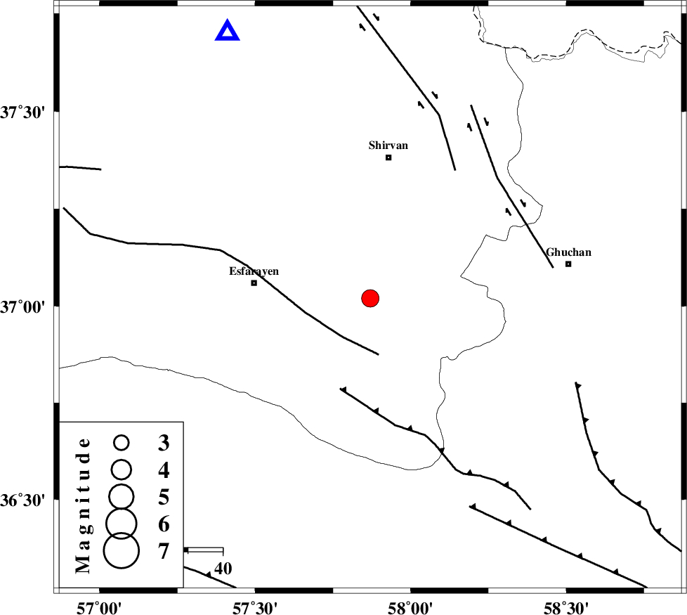
| Location | Lat:37.02 Lon: 57.87 |
| Region | Khorasan(north) Province, 33 km East of Esfarayen |
Nearest Cities |
|
| 14 km North of Bam, Khorasan(north) Province | |
| 23 km South of Geliyan, Khorasan(north) Province | |
| 25 km East of Parkanlu, Khorasan(north) Province | |
| 26 km South West of Maviyan, Khorasan(center) Province | |
| 30 km South West of Chari, Khorasan(center) Province | |
| Depth | 6 km |
| Agency | |
Faults within 150 km: |
|
| ESFARAYEN_F (Length: 111 km) , Distance to epicenter: 14 km | |
| RIVAND_F (Length: 70 km) , Distance to epicenter: 27 km | |
| BAGHAN_GERMAB_F (Length: 79 km) , Distance to epicenter: 44 km | |
| Number of Phases | 5 |
| RMS | 0.1 |
| Number of Stations | 4 |
| Error in Latitude | >4.1 km |
| Error in Longitude | 7 km |
| Error in Depth | 8.2 km |
Download waveform in seisan format
to download seisan software Click here
to access information about IIEES stations Click here
Amplitude | ||||||||
| UID | Agency | Station | Component | Amplitude | Period | Arrival Time | Proccessing Time | Signal Clip |
| 85764 | IIEES | MRVT | N | 580 | 0.29 | 2012-08-25 06:33:12 | 2012-08-25 07:16:00 | n |
| 85765 | IIEES | MRVT | E | 700.6 | 0.43 | 2012-08-25 06:33:14 | 2012-08-25 07:16:00 | n |
| 85766 | IIEES | SHRO | E | 289.1 | 0.63 | 2012-08-25 06:33:19 | 2012-08-25 07:16:00 | n |
| 85767 | IIEES | SHRO | N | 474.7 | 0.75 | 2012-08-25 06:33:20 | 2012-08-25 07:16:00 | n |
Phase | ||||||||||||
| Agency | Station | Component | Phase Type | Phase Quality | First Motion | Observed Arrival Time | Time Residual | Loc. Flag | Input Weight | Distance | Azimuth | |
| IIEES | BJRD | Z | Pg | E | 2012-08-25 06:32:32 | -0.05 | y | 85.4 | 331 | |||
| IIEES | MRVT | Z | Pn | E | 2012-08-25 06:32:48 | 0.11 | y | 173 | 295 | |||
| IIEES | MRVT | N | S | E | 2012-08-25 06:33:07 | -0.03 | y | 173 | 295 | |||
| IIEES | SHRO | Z | Pn | E | 2012-08-25 06:32:51 | 0.02 | y | 201 | 236 | |||
| IIEES | YZKH | Z | Pn | E | 2012-08-25 06:33:40 | -0.1 | y | 595 | 211 | |||