
Magnitude |
:3.1 |
| Date & Time (UTC) | 2012-08-23 18:07:56.9 |
| Date & Time (Local) | 1391/6/2 22:37:56.9 |
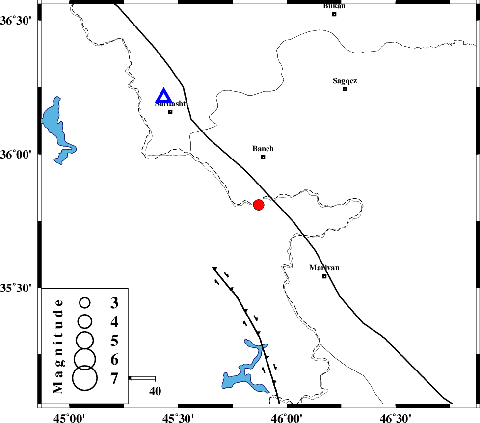
| Location | Lat:35.81 Lon: 45.87 |
| Region | Kordestan Province, 20 km South of Baneh |
Nearest Cities |
|
| 11 km East of Balekeh, Kurdistan Province | |
| 12 km of Armarde, Kurdistan Province | |
| 16 km South of Buein-esofla, Kurdistan Province | |
| 16 km West of Nanur, Kurdistan Province | |
| 20 km South of Baneh, Kurdistan Province | |
| Depth | 14 km |
| Agency | |
Faults within 150 km: |
|
| PIRANSHAHR_F (Length: 253 km) , Distance to epicenter: 15 km | |
| HZF4 (Length: 492 km) , Distance to epicenter: 32 km | |
| SARTAKHT_F (Length: 78 km) , Distance to epicenter: 120 km | |
| Number of Phases | 5 |
| RMS | 0.1 |
| Number of Stations | 3 |
| Error in Latitude | >2.2 km |
| Error in Longitude | 4.9 km |
| Error in Depth | 7.1 km |
Download waveform in seisan format
to download seisan software Click here
to access information about IIEES stations Click here
Amplitude | ||||||||
| UID | Agency | Station | Component | Amplitude | Period | Arrival Time | Proccessing Time | Signal Clip |
| 85725 | IIEES | SNGE | N | 328.3 | 0.64 | 2012-08-23 18:08:47 | 2012-08-23 06:37:00 | n |
| 85726 | IIEES | SNGE | E | 301.5 | 0.6 | 2012-08-23 18:08:48 | 2012-08-23 06:37:00 | n |
Phase | ||||||||||||
| Agency | Station | Component | Phase Type | Phase Quality | First Motion | Observed Arrival Time | Time Residual | Loc. Flag | Input Weight | Distance | Azimuth | |
| IIEES | SNGE | Z | Pg | E | 2012-08-23 18:08:22 | -0.11 | y | 156 | 120 | |||
| IIEES | SNGE | E | Sg | E | 2012-08-23 18:08:42 | 0.05 | y | 156 | 120 | |||
| IIEES | ZNJK | Z | Pn | E | 2012-08-23 18:08:38 | 0.15 | y | 271 | 69 | |||
| IIEES | ZNJK | N | Sg | E | 2012-08-23 18:09:13 | -0.04 | y | 271 | 69 | |||
| IIEES | GRMI | Z | Pn | E | 2012-08-23 18:08:51 | -0.05 | y | 378 | 28 | |||