
Magnitude |
:3.6 |
| Date & Time (UTC) | 2012-08-02 07:10:56.2 |
| Date & Time (Local) | 1391/5/12 11:40:56.2 |
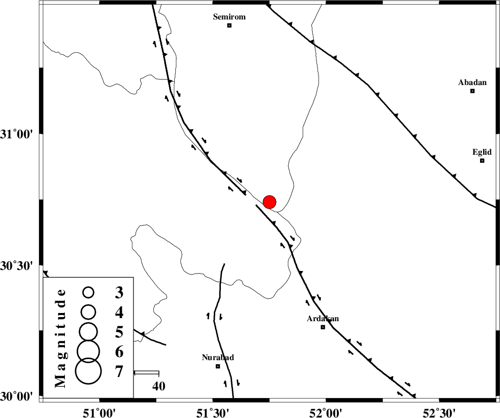
| Location | Lat:30.74 Lon: 51.75 |
| Region | Esfahan Province, 18 km East of Yasuj |
Nearest Cities |
|
| 16 km South of Bideh, Esfahan Province | |
| 19 km North East of Yasuj, Kohkiluieh va boyerahmad Province | |
| 22 km North East of Tal-e khosro, Kohkiluieh va boyerahmad Province | |
| 29 km North East of Hoseynabad, Kohkiluieh va boyerahmad Province | |
| 31 km South West of Khosro-o-shirin, Fars Province | |
| Depth | 15 km |
| Agency | |
Faults within 150 km: |
|
| HZF3 (Length: 197 km) , Distance to epicenter: 6 km | |
| DENA_F (Length: 137 km) , Distance to epicenter: 10 km | |
| KAZERUN_F (Length: 96 km) , Distance to epicenter: 32 km | |
| Number of Phases | 8 |
| RMS | 0.3 |
| Number of Stations | 8 |
| Error in Latitude | >2.2 km |
| Error in Longitude | 3 km |
| Error in Depth | 0 km |
Download waveform in seisan format
to download seisan software Click here
to access information about IIEES stations Click here
Amplitude | ||||||||
| UID | Agency | Station | Component | Amplitude | Period | Arrival Time | Proccessing Time | Signal Clip |
| 84703 | IIEES | AHRM | E | 595.9 | 0.84 | 2012-08-02 07:12:04 | 2012-08-02 07:40:00 | n |
| 84704 | IIEES | AHRM | N | 574.1 | 0.6 | 2012-08-02 07:12:09 | 2012-08-02 07:40:00 | n |
| 84705 | IIEES | GHIR | E | 187.2 | 0.44 | 2012-08-02 07:12:37 | 2012-08-02 07:40:00 | n |
| 84706 | IIEES | GHIR | N | 187.8 | 0.52 | 2012-08-02 07:12:44 | 2012-08-02 07:40:00 | n |
| 84707 | IIEES | ASAO | E | 54.8 | 0.68 | 2012-08-02 07:13:20 | 2012-08-02 07:40:00 | n |
Phase | ||||||||||||
| Agency | Station | Component | Phase Type | Phase Quality | First Motion | Observed Arrival Time | Time Residual | Loc. Flag | Input Weight | Distance | Azimuth | |
| IIEES | AHRM | Z | Pn | E | 2012-08-02 07:11:30 | 0.31 | y | 212 | 192 | |||
| IIEES | NASN | Z | Pn | E | 2012-08-02 07:11:34 | -0.24 | y | 250 | 23 | |||
| IIEES | GHIR | Z | Pn | E | 2012-08-02 07:11:40 | -0.37 | y | 297 | 156 | |||
| IIEES | YZKH | Z | Pn | E | 2012-08-02 07:11:44 | 0.29 | y | 326 | 55 | |||
| IIEES | KHMZ | Z | Pn | E | 2012-08-02 07:11:50 | -0.18 | y | 373 | 334 | |||
| IIEES | GHVR | Z | Pn | E | 2012-08-02 07:11:55 | 0.22 | y | 418 | 354 | |||
| IIEES | ASAO | Z | Pn | E | 2012-08-02 07:12:00 | 0.2 | y | 453 | 339 | |||
| IIEES | SNGE | Z | Pn | E | 2012-08-02 07:12:22 | -0.28 | y | 635 | 321 | |||