
Magnitude |
:1.9 |
| Date & Time (UTC) | 2012-07-25 07:26:59.2 |
| Date & Time (Local) | 1391/5/4 11:56:59.2 |
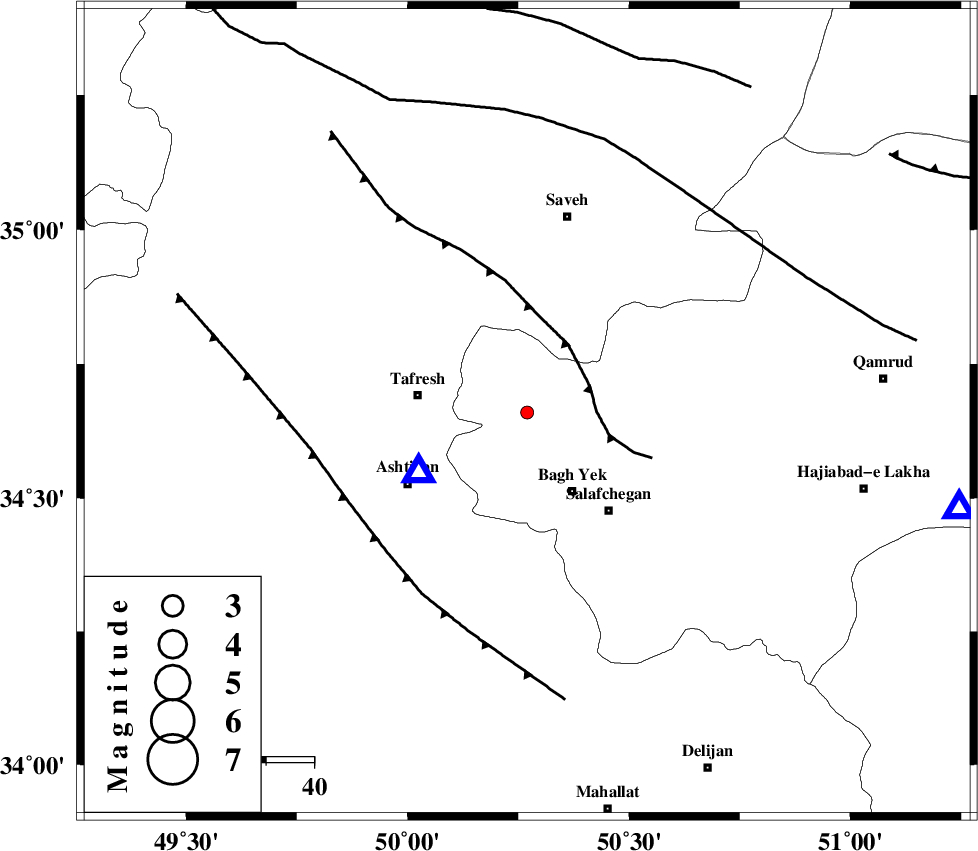
| Location | Lat:34.66 Lon: 50.27 |
| Region | Qom Province, 23 km East of Tafresh |
Nearest Cities |
|
| 13 km North of Dastjerd, Qom Province | |
| 19 km North West of Bagh yek, Qom Province | |
| 23 km East of Tafresh, Markazi Province | |
| 26 km North West of Salafchegan, Qom Province | |
| 27 km South West of Gazran, Qom Province | |
| Depth | 27 km |
| Agency | |
Faults within 150 km: |
|
| INDES_F (Length: 98 km) , Distance to epicenter: 14 km | |
| TAFRESH_F (Length: 117 km) , Distance to epicenter: 41 km | |
| KUSHK_E_NOSRAT_F (Length: 230 km) , Distance to epicenter: 56 km | |
| Number of Phases | 7 |
| RMS | 0.1 |
| Number of Stations | 5 |
| Error in Latitude | >1.7 km |
| Error in Longitude | 4.3 km |
| Error in Depth | 7.8 km |
Download waveform in seisan format
to download seisan software Click here
to access information about IIEES stations Click here
Amplitude | ||||||||
| UID | Agency | Station | Component | Amplitude | Period | Arrival Time | Proccessing Time | Signal Clip |
| 84583 | IIEES | GHVR | E | 31.7 | 0.36 | 2012-07-25 07:27:35 | 2012-07-25 08:05:00 | n |
| 84584 | IIEES | DAMV | E | 15.4 | 0.1 | 2012-07-25 07:27:55 | 2012-07-25 08:05:00 | n |
Phase | ||||||||||||
| Agency | Station | Component | Phase Type | Phase Quality | First Motion | Observed Arrival Time | Time Residual | Loc. Flag | Input Weight | Distance | Azimuth | |
| IIEES | ASAO | Z | Pg | E | 2012-07-25 07:27:05 | 0.07 | y | 25.7 | 241 | |||
| IIEES | GHVR | Z | Pg | E | 2012-07-25 07:27:14 | 0.01 | y | 91.7 | 102 | |||
| IIEES | KHMZ | Z | Pg | E | 2012-07-25 07:27:17 | 0.13 | y | 106 | 196 | |||
| IIEES | KHMZ | E | Sg | E | 2012-07-25 07:27:30 | -0.21 | y | 106 | 196 | |||
| IIEES | CHTH | Z | Pg | E | 2012-07-25 07:27:25 | 0.07 | y | 159 | 29 | |||
| IIEES | CHTH | E | Sg | E | 2012-07-25 07:27:44 | -0.23 | y | 159 | 29 | |||
| IIEES | DAMV | Z | Pg | E | 2012-07-25 07:27:30 | 0.16 | y | 189 | 55 | |||