
Magnitude |
:4.1 |
| Date & Time (UTC) | 2012-07-24 06:56:35.8 |
| Date & Time (Local) | 1391/5/3 11:26:35.8 |
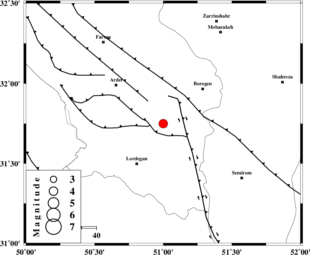
| Location | Lat:31.75 Lon: 51 |
| Region | Chaharmahal Bakhtiari Province, 34 km North-East of Lordegan |
Nearest Cities |
|
| 20 km South West of Gandoman, Chaharmahal Bakhtiari Province | |
| 20 km South of Baladaji, Chaharmahal Bakhtiari Province | |
| 23 km North of Aluni, Chaharmahal Bakhtiari Province | |
| 24 km North East of Armand-e olia, Chaharmahal Bakhtiari Province | |
| 32 km South East of Naghan, Chaharmahal Bakhtiari Province | |
| Depth | 17 km |
| Agency | |
Faults within 150 km: |
|
| DOPOLAN_F (Length: 107 km) , Distance to epicenter: 8 km | |
| SABZKUH_F (Length: 67 km) , Distance to epicenter: 9 km | |
| DENA_F (Length: 137 km) , Distance to epicenter: 14 km | |
| Number of Phases | 6 |
| RMS | 0.1 |
| Number of Stations | 5 |
| Error in Latitude | >1.5 km |
| Error in Longitude | 1.7 km |
| Error in Depth | 2.8 km |
Download waveform in seisan format
to download seisan software Click here
to access information about IIEES stations Click here
Amplitude | ||||||||
| UID | Agency | Station | Component | Amplitude | Period | Arrival Time | Proccessing Time | Signal Clip |
| 84574 | IIEES | SHGR | E | 1781.3 | 0.55 | 2012-07-24 06:57:50 | 2012-07-24 07:14:00 | n |
| 84575 | IIEES | SHGR | N | 1653.3 | 0.49 | 2012-07-24 06:57:55 | 2012-07-24 07:14:00 | n |
| 84576 | IIEES | KHMZ | E | 1239.7 | 0.44 | 2012-07-24 06:57:47 | 2012-07-24 07:14:00 | n |
| 84577 | IIEES | KHMZ | N | 946.4 | 0.52 | 2012-07-24 06:57:49 | 2012-07-24 07:14:00 | n |
Phase | ||||||||||||
| Agency | Station | Component | Phase Type | Phase Quality | First Motion | Observed Arrival Time | Time Residual | Loc. Flag | Input Weight | Distance | Azimuth | |
| IIEES | NASN | Z | Pg | E | 2012-07-24 06:57:09 | 0.03 | y | 206 | 55 | |||
| IIEES | SHGR | Z | Pg | E | 2012-07-24 06:57:10 | 0.04 | y | 212 | 281 | |||
| IIEES | KHMZ | Z | Pn | E | 2012-07-24 06:57:13 | 0 | y | 241 | 336 | |||
| IIEES | KHMZ | E | Sg | E | 2012-07-24 06:57:44 | -0.08 | y | 241 | 336 | |||
| IIEES | ASAO | Z | Pn | E | 2012-07-24 06:57:23 | 0.07 | y | 323 | 344 | |||
| IIEES | GHIR | Z | Pn | E | 2012-07-24 06:57:36 | -0.08 | y | 429 | 153 | |||