
Magnitude |
:4.8 |
| Date & Time (UTC) | 2012-07-24 06:50:06.9 |
| Date & Time (Local) | 1391/5/3 11:20:06.9 |
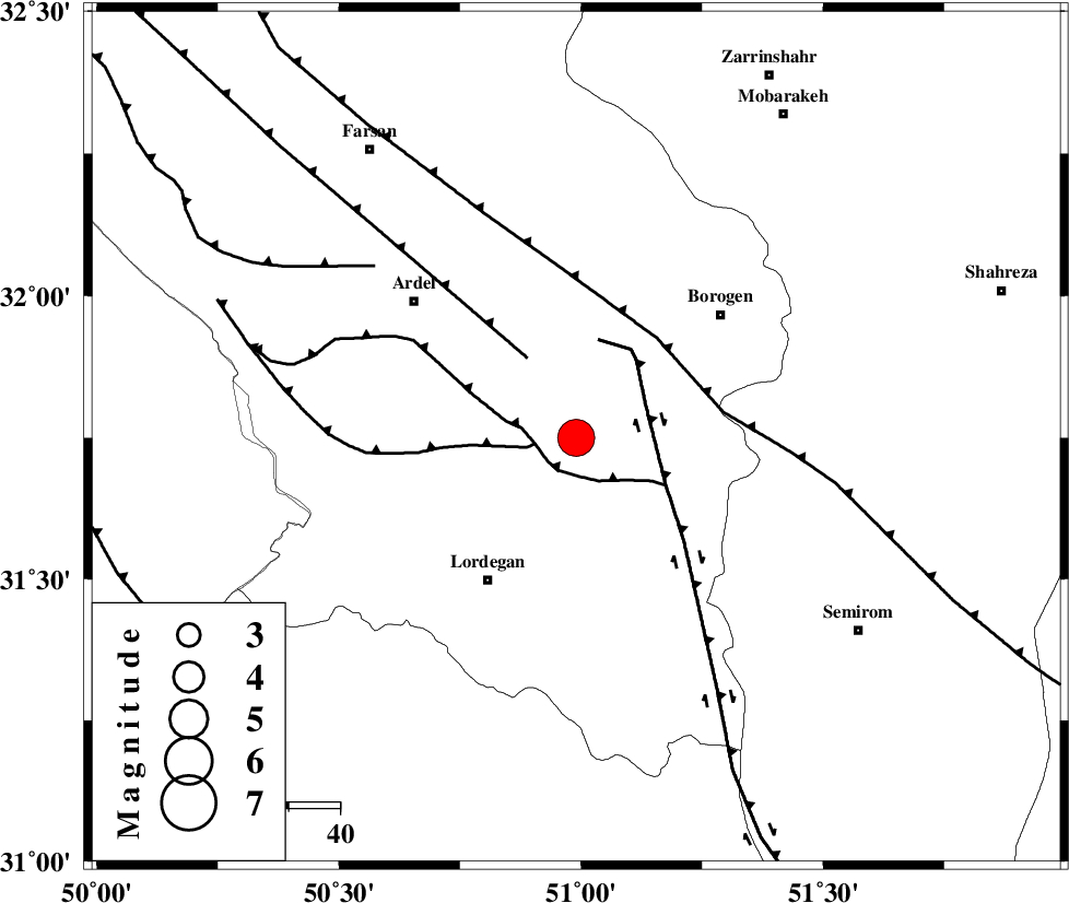
| Location | Lat:31.75 Lon: 50.99 |
| Region | Chaharmahal Bakhtiari Province, 33 km North-East of Lordegan |
Nearest Cities |
|
| 20 km South West of Gandoman, Chaharmahal Bakhtiari Province | |
| 21 km South of Baladaji, Chaharmahal Bakhtiari Province | |
| 23 km North East of Armand-e olia, Chaharmahal Bakhtiari Province | |
| 23 km North of Aluni, Chaharmahal Bakhtiari Province | |
| 32 km South East of Naghan, Chaharmahal Bakhtiari Province | |
| Depth | 15 km |
| Agency | |
Faults within 150 km: |
|
| DOPOLAN_F (Length: 107 km) , Distance to epicenter: 7 km | |
| SABZKUH_F (Length: 67 km) , Distance to epicenter: 8 km | |
| DENA_F (Length: 137 km) , Distance to epicenter: 15 km | |
| Number of Phases | 7 |
| RMS | 0.6 |
| Number of Stations | 7 |
| Error in Latitude | >6.1 km |
| Error in Longitude | 6.4 km |
| Error in Depth | 9.3 km |
Download waveform in seisan format
to download seisan software Click here
to access information about IIEES stations Click here
Amplitude | ||||||||
| UID | Agency | Station | Component | Amplitude | Period | Arrival Time | Proccessing Time | Signal Clip |
| 84572 | IIEES | SHGR | E | 9323.8 | 0.65 | 2012-07-24 06:51:19 | 2012-07-24 07:08:00 | n |
| 84573 | IIEES | SHGR | N | 9040.2 | 0.57 | 2012-07-24 06:51:20 | 2012-07-24 07:08:00 | n |
Phase | ||||||||||||
| Agency | Station | Component | Phase Type | Phase Quality | First Motion | Observed Arrival Time | Time Residual | Loc. Flag | Input Weight | Distance | Azimuth | |
| IIEES | NASN | Z | Pg | E | 2012-07-24 06:50:40 | -0.48 | y | 207 | 55 | |||
| IIEES | SHGR | Z | Pg | E | 2012-07-24 06:50:41 | -0.3 | y | 210 | 281 | |||
| IIEES | KHMZ | Z | Pn | E | 2012-07-24 06:50:44 | -0.13 | y | 240 | 337 | |||
| IIEES | GHVR | Z | Pn | E | 2012-07-24 06:50:52 | 0.71 | y | 303 | 4 | |||
| IIEES | AHRM | Z | Pn | E | 2012-07-24 06:50:55 | 0.72 | y | 321 | 175 | |||
| IIEES | GHIR | Z | Pn | E | 2012-07-24 06:51:07 | -0.93 | y | 430 | 153 | |||
| IIEES | KRBR | Z | P | E | 2012-07-24 06:51:28 | 0.53 | y | 586 | 108 | |||