
Magnitude |
:3.3 |
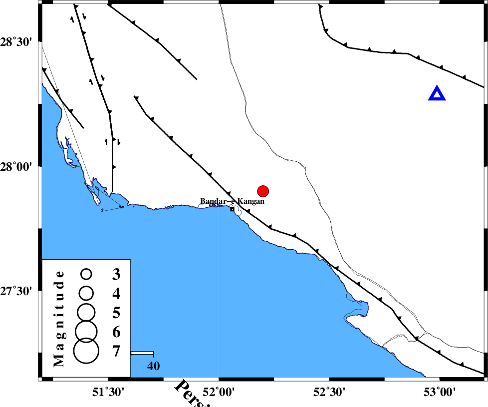
| Date & Time (UTC) | 2012-07-24 01:58:59.5 |
| Date & Time (Local) | 1391/5/3 06:28:59.5 |
| Location | Lat:27.9 Lon: 52.2 |
| Region | Bushehr Province, 14 km West of Jam |
Nearest Cities |
|
| 14 km North West of Jam, Bushehr Province | |
| 16 km North East of Bandar-e kangan, Bushehr Province | |
| 21 km South East of Riz, Bushehr Province | |
| 29 km South of Dolatabad, Fars Province | |
| 30 km North West of Bandar-e taheri, Bushehr Province | |
| Depth | 38 km |
| Agency | |
Faults within 150 km: |
|
| MFF3 (Length: 292 km) , Distance to epicenter: 12 km | |
| MFF5 (Length: 74 km) , Distance to epicenter: 58 km | |
| BORAZJAN_F (Length: 168 km) , Distance to epicenter: 67 km | |
| Number of Phases | 5 |
| RMS | 0.1 |
| Number of Stations | 3 |
| Error in Latitude | >7.4 km |
| Error in Longitude | 2.5 km |
| Error in Depth | 5 km |
Download waveform in seisan format
to download seisan software Click here
to access information about IIEES stations Click here
Amplitude | ||||||||
| UID | Agency | Station | Component | Amplitude | Period | Arrival Time | Proccessing Time | Signal Clip |
| 84567 | IIEES | GHIR | N | 996.5 | 0.3 | 2012-07-24 01:59:34 | 2012-07-24 02:27:00 | n |
| 84568 | IIEES | GHIR | E | 1128.5 | 0.36 | 2012-07-24 01:59:35 | 2012-07-24 02:27:00 | n |
| 84569 | IIEES | AHRM | N | 387.9 | 0.6 | 2012-07-24 01:59:53 | 2012-07-24 02:27:00 | n |
| 84570 | IIEES | KRBR | N | 29.6 | 0.36 | 2012-07-24 02:01:09 | 2012-07-24 02:27:00 | n |
| 84571 | IIEES | KRBR | E | 25.8 | 0.36 | 2012-07-24 02:01:11 | 2012-07-24 02:27:00 | n |
Phase | ||||||||||||
| Agency | Station | Component | Phase Type | Phase Quality | First Motion | Observed Arrival Time | Time Residual | Loc. Flag | Input Weight | Distance | Azimuth | |
| IIEES | GHIR | Z | Pg | E | 2012-07-24 01:59:14 | -0.17 | y | 88.8 | 61 | |||
| IIEES | GHIR | N | Sg | E | 2012-07-24 01:59:26 | 0.1 | y | 88.8 | 61 | |||
| IIEES | AHRM | Z | Pg | E | 2012-07-24 01:59:22 | 0.17 | y | 139 | 321 | |||
| IIEES | AHRM | N | Sg | E | 2012-07-24 01:59:39 | -0.1 | y | 139 | 321 | |||
| IIEES | KRBR | Z | Pn | E | 2012-07-24 02:00:07 | 0 | y | 501 | 61 | |||