
Magnitude |
:4 |
| Date & Time (UTC) | 2012-07-23 08:31:41.6 |
| Date & Time (Local) | 1391/5/2 13:01:41.6 |
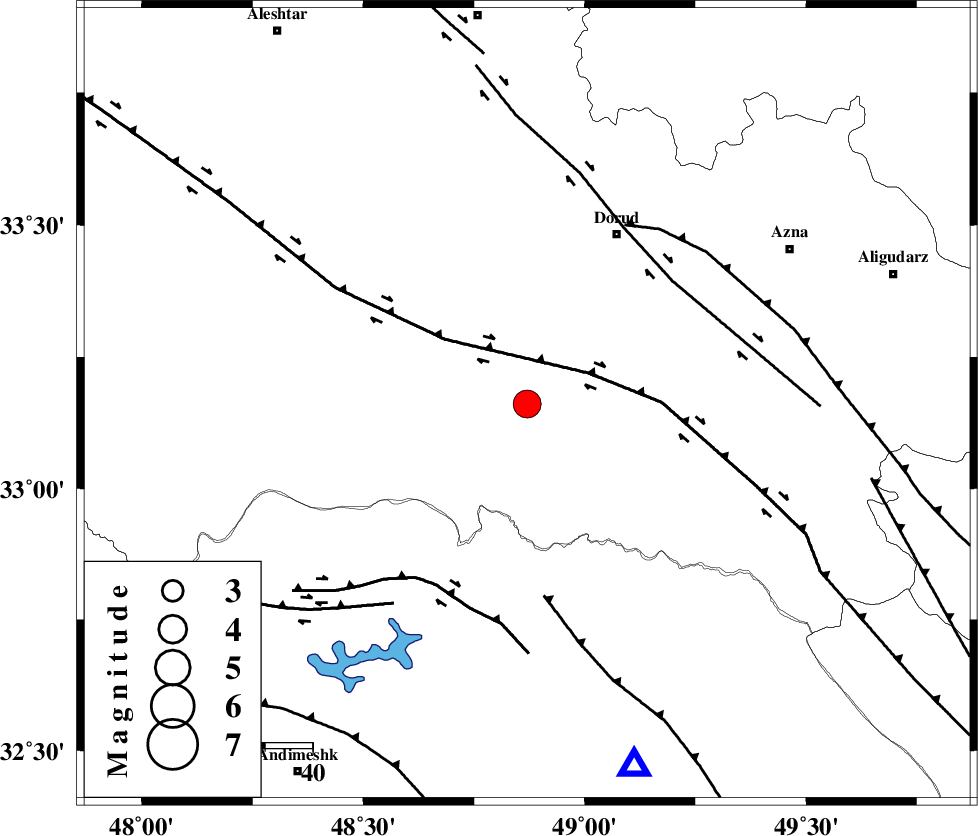
| Location | Lat:33.16 Lon: 48.87 |
| Region | Lorestan Province, 41 km South-West of Dorud |
Nearest Cities |
|
| 6 km of Chamsangar, Lorestan Province | |
| 14 km North of Bargsar, Lorestan Province | |
| 15 km South of Sartang barzeh, Lorestan Province | |
| 28 km West of Shulabad, Lorestan Province | |
| 34 km South East of Emanabad, Lorestan Province | |
| Depth | 14 km |
| Agency | |
Faults within 150 km: |
|
| HZF4 (Length: 492 km) , Distance to epicenter: 15 km | |
| DORUD (Length: 100 km) , Distance to epicenter: 40 km | |
| MFF2 (Length: 205 km) , Distance to epicenter: 41 km | |
| Number of Phases | 5 |
| RMS | 0.2 |
| Number of Stations | 6 |
| Error in Latitude | >2.5 km |
| Error in Longitude | 6.2 km |
| Error in Depth | 5.5 km |
Download waveform in seisan format
to download seisan software Click here
to access information about IIEES stations Click here
Amplitude | ||||||||
| UID | Agency | Station | Component | Amplitude | Period | Arrival Time | Proccessing Time | Signal Clip |
| 84549 | IIEES | SHGR | N | 3263.1 | 0.5 | 2012-07-23 08:32:24 | 2012-07-23 08:50:00 | n |
| 84550 | IIEES | ASAO | E | 1561.7 | 0.64 | 2012-07-23 08:32:42 | 2012-07-23 08:50:00 | n |
| 84551 | IIEES | GHVR | N | 576.1 | 0.54 | 2012-07-23 08:33:04 | 2012-07-23 08:50:00 | n |
| 84552 | IIEES | GHVR | E | 859.1 | 0.58 | 2012-07-23 08:33:06 | 2012-07-23 08:50:00 | n |
Phase | ||||||||||||
| Agency | Station | Component | Phase Type | Phase Quality | First Motion | Observed Arrival Time | Time Residual | Loc. Flag | Input Weight | Distance | Azimuth | |
| IIEES | SHGR | Z | Pg | E | 2012-07-23 08:32:01 | -0.03 | y | 116 | 183 | |||
| IIEES | ASAO | Z | Pg | E | 2012-07-23 08:32:12 | -0.23 | y | 188 | 34 | |||
| IIEES | NASN | Z | Pn | E | 2012-07-23 08:32:35 | -0.01 | y | 370 | 95 | |||
| IIEES | DAMV | Z | Pn | E | 2012-07-23 08:32:39 | 0.32 | y | 396 | 45 | |||
| IIEES | GRMI | Z | Pn | E | 2012-07-23 08:33:08 | 0.05 | y | 633 | 352 | |||