
Magnitude |
:2.8 |
| Date & Time (UTC) | 2012-07-18 04:28:04.0 |
| Date & Time (Local) | 1391/4/28 08:58:04.0 |
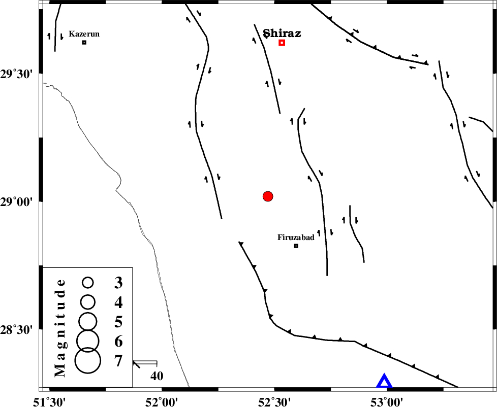
| Location | Lat:29.02 Lon: 52.47 |
| Region | Fars Province, 25 km North-West of Firuz Abad |
Nearest Cities |
|
| 13 km West of Jokan, Fars Province | |
| 23 km North of Ahmadabad, Fars Province | |
| 25 km North West of Firuz Abad, Fars Province | |
| 26 km East of Dadanjan, Fars Province | |
| 31 km North West of Meymand, Fars Province | |
| Depth | 6 km |
| Agency | |
Faults within 150 km: |
|
| KAREBASS_F (Length: 98 km) , Distance to epicenter: 22 km | |
| SABZ_PUSHAN_F_Z1 (Length: 69 km) , Distance to epicenter: 22 km | |
| QIR_F (Length: 130 km) , Distance to epicenter: 23 km | |
| Number of Phases | 5 |
| RMS | 0.1 |
| Number of Stations | 3 |
| Error in Latitude | >5.7 km |
| Error in Longitude | 3.2 km |
| Error in Depth | 12.1 km |
Download waveform in seisan format
to download seisan software Click here
to access information about IIEES stations Click here
Amplitude | ||||||||
| UID | Agency | Station | Component | Amplitude | Period | Arrival Time | Proccessing Time | Signal Clip |
| 84486 | IIEES | GHIR | E | 341.3 | 0.51 | 2012-07-18 04:28:39 | 2012-07-18 05:41:00 | n |
| 84487 | IIEES | GHIR | N | 244.7 | 0.36 | 2012-07-18 04:28:39 | 2012-07-18 05:41:00 | n |
Phase | ||||||||||||
| Agency | Station | Component | Phase Type | Phase Quality | First Motion | Observed Arrival Time | Time Residual | Loc. Flag | Input Weight | Distance | Azimuth | |
| IIEES | GHIR | Z | Pg | E | 2012-07-18 04:28:20 | -0.01 | y | 96 | 148 | |||
| IIEES | GHIR | E | Sg | E | 2012-07-18 04:28:33 | 0.02 | y | 96 | 148 | |||
| IIEES | AHRM | Z | Pg | E | 2012-07-18 04:28:24 | 0 | y | 116 | 262 | |||
| IIEES | AHRM | N | Sg | E | 2012-07-18 04:28:38 | -0.18 | y | 116 | 262 | |||
| IIEES | KRBR | Z | Pn | E | 2012-07-18 04:29:06 | 0.22 | y | 429 | 75 | |||