
Magnitude |
:2 |
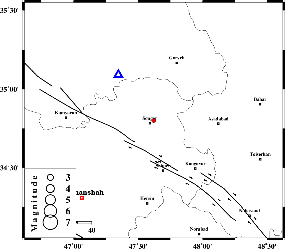
| Date & Time (UTC) | 2012-07-14 09:53:06.6 |
| Date & Time (Local) | 1391/4/24 14:23:06.6 |
| Location | Lat:34.8 Lon: 47.62 |
| Region | Kermanshah Province, 3 km Sonqor |
Nearest Cities |
|
| 3 km North of Sonqor, Kermanshah Province | |
| 11 km North of Gaznahleh, Kermanshah Province | |
| 12 km of Bavoleh, Kermanshah Province | |
| 13 km South of Qamam, Kermanshah Province | |
| 13 km West of Abbarik-e olia, Kermanshah Province | |
| Depth | 14 km |
| Agency | |
Faults within 150 km: |
|
| SARTAKHT_F (Length: 78 km) , Distance to epicenter: 21 km | |
| DINEHVAR_F (Length: 46 km) , Distance to epicenter: 22 km | |
| SAHANEH_F (Length: 77 km) , Distance to epicenter: 29 km | |
| Number of Phases | 5 |
| RMS | 0.1 |
| Number of Stations | 3 |
| Error in Latitude | >9.5 km |
| Error in Longitude | 5.2 km |
| Error in Depth | 6.2 km |
Download waveform in seisan format
to download seisan software Click here
to access information about IIEES stations Click here
Amplitude | ||||||||
| UID | Agency | Station | Component | Amplitude | Period | Arrival Time | Proccessing Time | Signal Clip |
| 84476 | IIEES | ASAO | E | 9.8 | 0.38 | 2012-07-14 09:54:16 | 2012-07-14 10:57:00 | n |
| 84477 | IIEES | KHMZ | N | 9.6 | 0.41 | 2012-07-14 09:54:23 | 2012-07-14 10:57:00 | n |
Phase | ||||||||||||
| Agency | Station | Component | Phase Type | Phase Quality | First Motion | Observed Arrival Time | Time Residual | Loc. Flag | Input Weight | Distance | Azimuth | |
| IIEES | SNGE | Z | Pg | E | 2012-07-14 09:53:14 | 0.01 | y | 41.6 | 323 | |||
| IIEES | ASAO | Z | Pg | E | 2012-07-14 09:53:42 | -0.13 | y | 222 | 96 | |||
| IIEES | ASAO | E | Sg | E | 2012-07-14 09:54:09 | 0.07 | y | 222 | 96 | |||
| IIEES | KHMZ | Z | Pn | E | 2012-07-14 09:53:45 | 0.1 | y | 245 | 118 | |||
| IIEES | KHMZ | N | Sn | 2012-07-14 09:54:12 | -0.05 | y | 245 | 118 | ||||