
Magnitude |
:1.9 |
| Date & Time (UTC) | 2012-07-13 16:50:06.7 |
| Date & Time (Local) | 1391/4/23 21:20:06.7 |
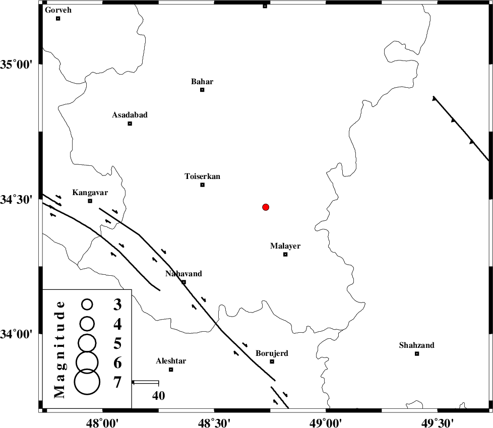
| Location | Lat:34.47 Lon: 48.73 |
| Region | Hamedan Province, 21 km North of Malayer |
Nearest Cities |
|
| 6 km North of Jokar, Hamedan Province | |
| 16 km North of Mehrabad, Hamedan Province | |
| 19 km North East of Seyyed shahab, Hamedan Province | |
| 21 km North of Malayer, Hamedan Province | |
| 22 km West of Eslamabad, Hamedan Province | |
| Depth | 14 km |
| Agency | |
Faults within 150 km: |
|
| NAHAVAND_F (Length: 102 km) , Distance to epicenter: 46 km | |
| SAHANEH_F (Length: 77 km) , Distance to epicenter: 55 km | |
| DORUD (Length: 100 km) , Distance to epicenter: 74 km | |
| Number of Phases | 4 |
| RMS | 0 |
| Number of Stations | 4 |
| Error in Latitude | >4.1 km |
| Error in Longitude | 2.6 km |
| Error in Depth | 4.3 km |
Download waveform in seisan format
to download seisan software Click here
to access information about IIEES stations Click here
Amplitude | ||||||||
| UID | Agency | Station | Component | Amplitude | Period | Arrival Time | Proccessing Time | Signal Clip |
| 84463 | IIEES | ASAO | E | 16.2 | 0.6 | 2012-07-13 16:50:45 | 2012-07-13 06:02:00 | n |
| 84464 | IIEES | KHMZ | N | 25.5 | 0.4 | 2012-07-13 16:50:48 | 2012-07-13 06:02:00 | n |
| 84465 | IIEES | KHMZ | E | 28.9 | 0.28 | 2012-07-13 16:50:50 | 2012-07-13 06:02:00 | n |
| 84466 | IIEES | SNGE | N | 35.8 | 0.2 | 2012-07-13 16:50:49 | 2012-07-13 06:02:00 | n |
Phase | ||||||||||||
| Agency | Station | Component | Phase Type | Phase Quality | First Motion | Observed Arrival Time | Time Residual | Loc. Flag | Input Weight | Distance | Azimuth | |
| IIEES | ASAO | Z | Pg | E | 2012-07-13 16:50:26 | -0.01 | y | 119 | 85 | |||
| IIEES | KHMZ | Z | Pg | E | 2012-07-13 16:50:30 | 0 | y | 139 | 125 | |||
| IIEES | SNGE | Z | Pg | E | 2012-07-13 16:50:30 | 0 | y | 144 | 299 | |||
| IIEES | GHVR | Z | Pn | E | 2012-07-13 16:50:43 | 0.01 | y | 231 | 89 | |||