
Magnitude |
:2.4 |
| Date & Time (UTC) | 2012-07-02 04:55:40.2 |
| Date & Time (Local) | 1391/4/12 09:25:40.2 |
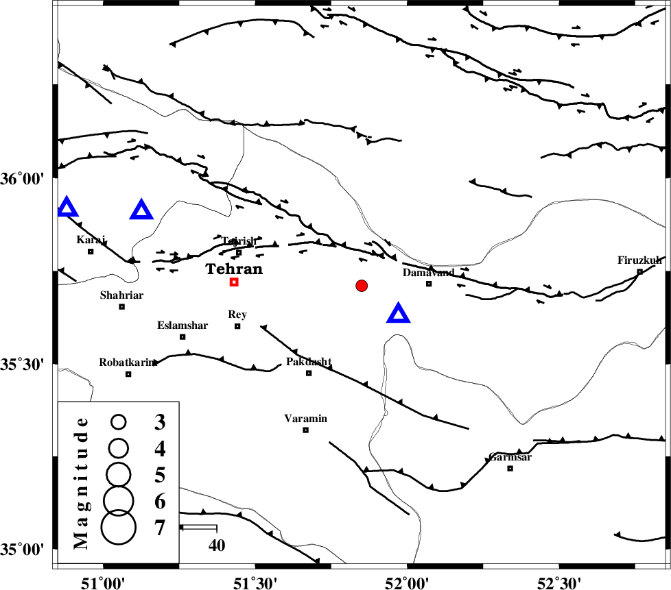
| Location | Lat:35.71 Lon: 51.85 |
| Region | Tehran Province, 20 km West of Damavand |
Nearest Cities |
|
| 4 km of Rudehen, Tehran Province | |
| 4 km of Bumehen, Tehran Province | |
| 15 km West of Abali, Tehran Province | |
| 16 km South East of Lavasan, Tehran Province | |
| 16 km North West of Ab sard, Tehran Province | |
| Depth | 7 km |
| Agency | |
Faults within 150 km: |
|
| MOSHA_F (Length: 234 km) , Distance to epicenter: 11 km | |
| N_TEHRAN_F4 (Length: 115 km) , Distance to epicenter: 14 km | |
| EYVANEKEY_F (Length: 74 km) , Distance to epicenter: 28 km | |
| Number of Phases | 6 |
| RMS | 0.3 |
| Number of Stations | 5 |
| Error in Latitude | >6.6 km |
| Error in Longitude | 7.2 km |
| Error in Depth | 8.1 km |
Download waveform in seisan format
to download seisan software Click here
to access information about IIEES stations Click here
Amplitude | ||||||||
| UID | Agency | Station | Component | Amplitude | Period | Arrival Time | Proccessing Time | Signal Clip |
| 84359 | IIEES | DAMV | E | 1978.9 | 0.14 | 2012-07-02 04:55:46 | 2012-07-02 05:32:00 | n |
| 84360 | IIEES | GHVR | E | 44.9 | 0.23 | 2012-07-02 04:56:29 | 2012-07-02 05:32:00 | n |
Phase | ||||||||||||
| Agency | Station | Component | Phase Type | Phase Quality | First Motion | Observed Arrival Time | Time Residual | Loc. Flag | Input Weight | Distance | Azimuth | |
| IIEES | DAMV | Z | Pg | E | 2012-07-02 04:55:42 | -0.46 | y | 14.1 | 128 | |||
| IIEES | DAMV | E | Sg | E | 2012-07-02 04:55:45 | 0.37 | y | 14.1 | 128 | |||
| IIEES | CHTH | Z | Pg | E | 2012-07-02 04:55:52 | -0.24 | y | 68.9 | 289 | |||
| IIEES | THKV | Z | Pg | E | 2012-07-02 04:55:56 | 0.36 | y | 90.5 | 285 | |||
| IIEES | GHVR | Z | Pg | E | 2012-07-02 04:56:05 | -0.15 | y | 147 | 202 | |||
| IIEES | ASAO | Z | Pn | E | 2012-07-02 04:56:15 | 0.12 | y | 210 | 233 | |||