
Magnitude |
:2.7 |
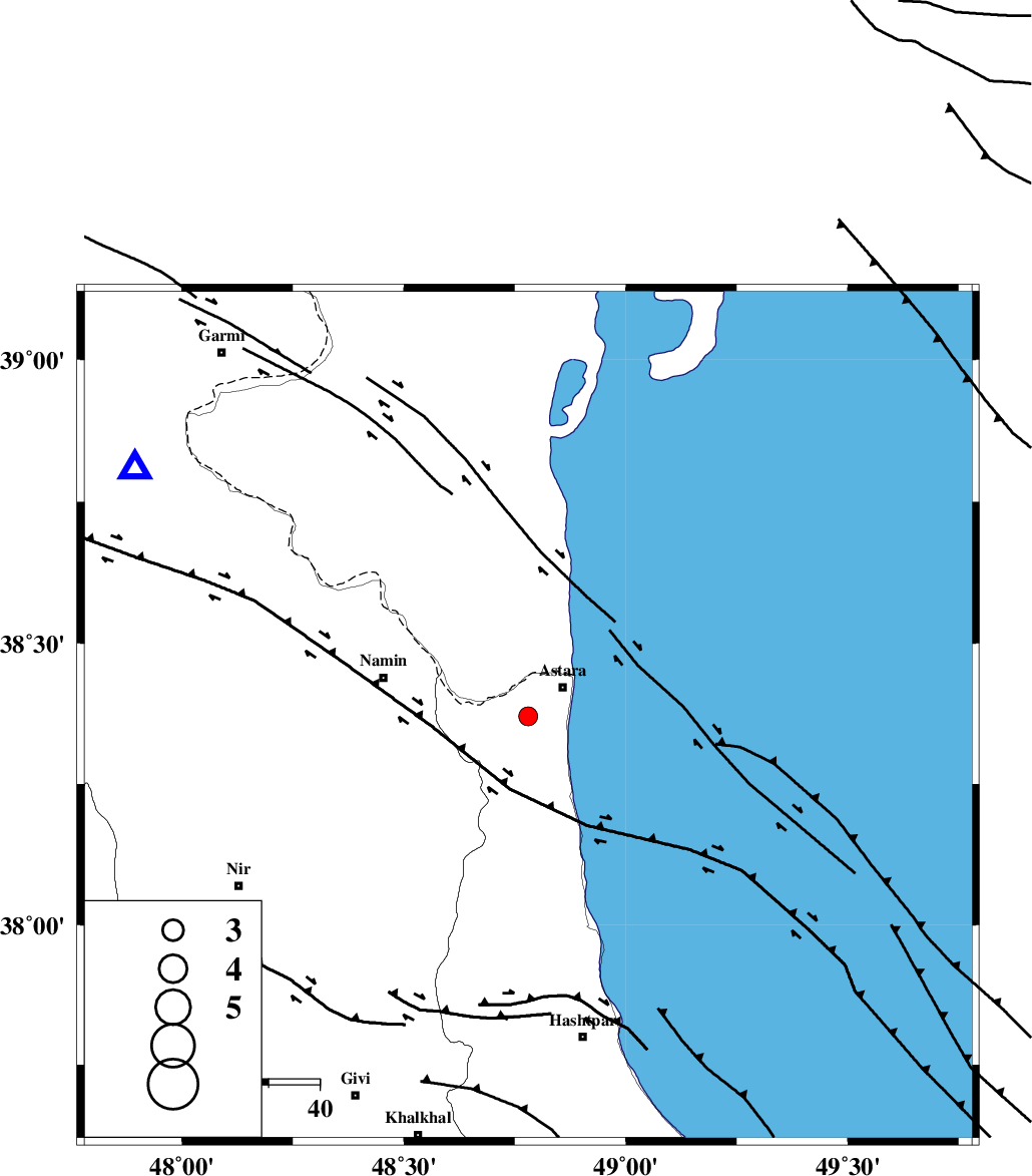
| Date & Time (UTC) | 2012-06-16 13:07:33.9 |
| Date & Time (Local) | 1391/3/27 17:37:33.9 |
| Location | Lat:38.37 Lon: 48.78 |
| Region | Gilan Province, 9 km Astara |
Nearest Cities |
|
| 9 km of Astara, Gilan Province | |
| 9 km North of Londovil, Gilan Province | |
| 11 km East of Kiladeh, Gilan Province | |
| 21 km North East of Baibiglu, Ardebil Province | |
| 22 km North East of Nanehkaran, Ardebil Province | |
| Depth | 17 km |
| Agency | |
Faults within 150 km: |
|
| TALESH_F (Length: 258 km) , Distance to epicenter: 10 km | |
| SANGAVAR_F (Length: 61 km) , Distance to epicenter: 26 km | |
| BOZQUSH (Length: 70 km) , Distance to epicenter: 52 km | |
| Number of Phases | 6 |
| RMS | 0.1 |
| Number of Stations | 3 |
| Error in Latitude | >2.2 km |
| Error in Longitude | 5.1 km |
| Error in Depth | 5 km |
Download waveform in seisan format
to download seisan software Click here
to access information about IIEES stations Click here
Amplitude | ||||||||
| UID | Agency | Station | Component | Amplitude | Period | Arrival Time | Proccessing Time | Signal Clip |
| 84167 | IIEES | GRMI | E | 250.2 | 0.4 | 2012-06-16 13:08:01 | 2012-06-16 01:55:00 | n |
| 84168 | IIEES | ZNJK | N | 80.9 | 0.32 | 2012-06-16 13:08:31 | 2012-06-16 01:55:00 | n |
Phase | ||||||||||||
| Agency | Station | Component | Phase Type | Phase Quality | First Motion | Observed Arrival Time | Time Residual | Loc. Flag | Input Weight | Distance | Azimuth | |
| IIEES | GRMI | Z | Pg | E | 2012-06-16 13:07:49 | 0.15 | y | 91.2 | 302 | |||
| IIEES | GRMI | N | Sg | E | 2012-06-16 13:08:00 | -0.11 | y | 91.2 | 302 | |||
| IIEES | ZNJK | Z | Pn | I | 2012-06-16 13:08:05 | 0.06 | y | 189 | 183 | |||
| IIEES | ZNJK | Z | Pg | E | 2012-06-16 13:08:05 | -0.04 | y | 189 | 183 | |||
| IIEES | ZNJK | N | Sg | E | 2012-06-16 13:08:27 | 0.01 | y | 189 | 183 | |||
| IIEES | CHTH | Z | Pn | E | 2012-06-16 13:08:24 | -0.07 | y | 344 | 142 | |||