
Magnitude |
:3.7 |
| Date & Time (UTC) | 2012-06-06 22:14:43.5 |
| Date & Time (Local) | 1391/3/18 02:44:43.5 |
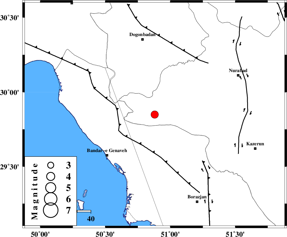
| Location | Lat:29.85 Lon: 50.88 |
| Region | Fars Province, 56 km South of Dogonbadan |
Nearest Cities |
|
| 34 km North East of Mohammad salehi, Bushehr Province | |
| 35 km North of Chehar rustaee, Bushehr Province | |
| 39 km South West of Babamonir, Fars Province | |
| 43 km North West of Dehkohneh, Bushehr Province | |
| 47 km North East of Bandar-e genaveh, Bushehr Province | |
| Depth | 18 km |
| Agency | |
Faults within 150 km: |
|
| ZFF3 (Length: 125 km) , Distance to epicenter: 25 km | |
| BORAZJAN_F (Length: 168 km) , Distance to epicenter: 50 km | |
| MISHAN_F (Length: 76 km) , Distance to epicenter: 52 km | |
| Number of Phases | 6 |
| RMS | 0.1 |
| Number of Stations | 4 |
| Error in Latitude | >2.9 km |
| Error in Longitude | 3.3 km |
| Error in Depth | 5.9 km |
Download waveform in seisan format
to download seisan software Click here
to access information about IIEES stations Click here
Amplitude | ||||||||
| UID | Agency | Station | Component | Amplitude | Period | Arrival Time | Proccessing Time | Signal Clip |
| 83989 | IIEES | AHRM | E | 1507.8 | 0.56 | 2012-06-06 22:15:25 | 2012-06-06 10:51:00 | n |
| 83990 | IIEES | AHRM | N | 1311.2 | 0.6 | 2012-06-06 22:15:26 | 2012-06-06 10:51:00 | n |
| 83991 | IIEES | GHIR | N | 295.9 | 0.6 | 2012-06-06 22:16:18 | 2012-06-06 10:51:00 | n |
| 83992 | IIEES | GHIR | E | 277.5 | 0.64 | 2012-06-06 22:16:19 | 2012-06-06 10:51:00 | n |
| 83993 | IIEES | SHGR | E | 410.1 | 0.52 | 2012-06-06 22:16:20 | 2012-06-06 10:51:00 | n |
| 83994 | IIEES | SHGR | N | 314.7 | 0.44 | 2012-06-06 22:16:21 | 2012-06-06 10:51:00 | n |
Phase | ||||||||||||
| Agency | Station | Component | Phase Type | Phase Quality | First Motion | Observed Arrival Time | Time Residual | Loc. Flag | Input Weight | Distance | Azimuth | |
| IIEES | AHRM | Z | Pg | E | 2012-06-06 22:15:03 | -0.1 | y | 117 | 160 | |||
| IIEES | AHRM | N | Sg | E | 2012-06-06 22:15:17 | 0.01 | y | 117 | 160 | |||
| IIEES | GHIR | Z | Pn | E | 2012-06-06 22:15:24 | -0.09 | y | 269 | 130 | |||
| IIEES | GHIR | E | Sg | E | 2012-06-06 22:15:59 | 0.11 | y | 269 | 130 | |||
| IIEES | SHGR | Z | Pn | E | 2012-06-06 22:15:30 | 0.15 | y | 319 | 322 | |||
| IIEES | KHMZ | Z | Pn | E | 2012-06-06 22:15:45 | -0.09 | y | 440 | 349 | |||