
Magnitude |
:2.9 |
| Date & Time (UTC) | 2012-06-06 21:18:11.3 |
| Date & Time (Local) | 1391/3/18 01:48:11.3 |
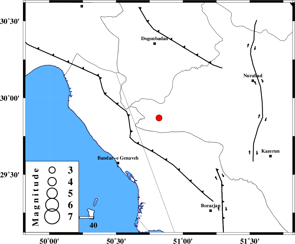
| Location | Lat:29.87 Lon: 50.82 |
| Region | Fars Province, 54 km South of Dogonbadan |
Nearest Cities |
|
| 32 km North East of Mohammad salehi, Bushehr Province | |
| 36 km North of Chehar rustaee, Bushehr Province | |
| 43 km South West of Babamonir, Fars Province | |
| 44 km North East of Bandar-e genaveh, Bushehr Province | |
| 47 km North East of Bandarehrig, Bushehr Province | |
| Depth | 18 km |
| Agency | |
Faults within 150 km: |
|
| ZFF3 (Length: 125 km) , Distance to epicenter: 22 km | |
| RAG_E_SEFID_F (Length: 84 km) , Distance to epicenter: 52 km | |
| MISHAN_F (Length: 76 km) , Distance to epicenter: 53 km | |
| Number of Phases | 5 |
| RMS | 0.1 |
| Number of Stations | 3 |
| Error in Latitude | >3 km |
| Error in Longitude | 3.7 km |
| Error in Depth | 5.9 km |
Download waveform in seisan format
to download seisan software Click here
to access information about IIEES stations Click here
Amplitude | ||||||||
| UID | Agency | Station | Component | Amplitude | Period | Arrival Time | Proccessing Time | Signal Clip |
| 83979 | IIEES | AHRM | E | 269.3 | 0.4 | 2012-06-06 21:18:53 | 2012-06-06 09:51:00 | n |
| 83980 | IIEES | AHRM | N | 290.8 | 0.56 | 2012-06-06 21:18:55 | 2012-06-06 09:51:00 | n |
| 83981 | IIEES | GHIR | E | 59.2 | 0.44 | 2012-06-06 21:19:39 | 2012-06-06 09:51:00 | n |
| 83982 | IIEES | GHIR | N | 53.8 | 0.4 | 2012-06-06 21:19:41 | 2012-06-06 09:51:00 | n |
Phase | ||||||||||||
| Agency | Station | Component | Phase Type | Phase Quality | First Motion | Observed Arrival Time | Time Residual | Loc. Flag | Input Weight | Distance | Azimuth | |
| IIEES | AHRM | Z | Pg | E | 2012-06-06 21:18:31 | -0.01 | y | 120 | 157 | |||
| IIEES | AHRM | N | Sg | E | 2012-06-06 21:18:46 | -0.01 | y | 120 | 157 | |||
| IIEES | GHIR | Z | Pn | E | 2012-06-06 21:18:52 | -0.15 | y | 274 | 129 | |||
| IIEES | GHIR | E | Sg | E | 2012-06-06 21:19:28 | 0.08 | y | 274 | 129 | |||
| IIEES | KHMZ | Z | P | E | 2012-06-06 21:19:13 | 0.11 | y | 437 | 350 | |||