
Magnitude |
:1.8 |
| Date & Time (UTC) | 2012-06-05 04:25:03.4 |
| Date & Time (Local) | 1391/3/16 08:55:03.4 |
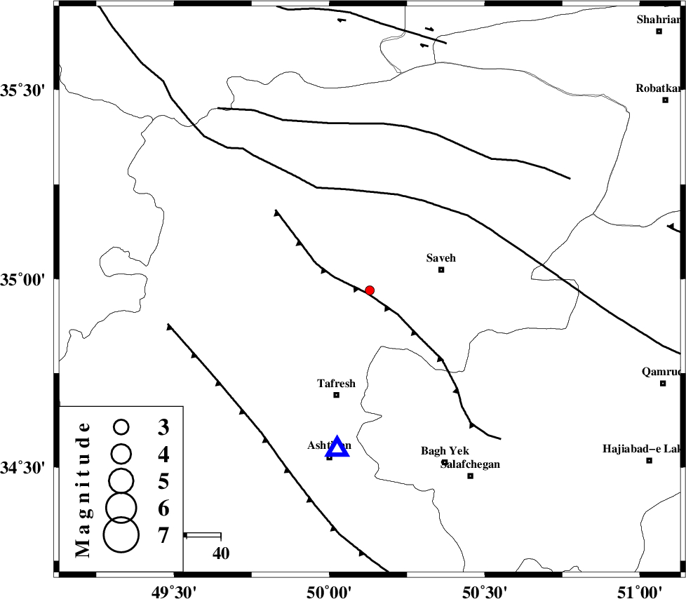
| Location | Lat:34.97 Lon: 50.13 |
| Region | Markazi Province, 22 km West of Saveh |
Nearest Cities |
|
| 13 km of Qeytaniyeh, Markazi Province | |
| 14 km North of Khanak, Markazi Province | |
| 16 km North West of Yalabad, Markazi Province | |
| 22 km West of Saveh, Markazi Province | |
| 23 km North West of Qareh chay, Markazi Province | |
| Depth | 17 km |
| Agency | |
Faults within 150 km: |
|
| INDES_F (Length: 98 km) , Distance to epicenter: 1 km | |
| KUSHK_E_NOSRAT_F (Length: 230 km) , Distance to epicenter: 29 km | |
| S_PARANDAK_F (Length: 116 km) , Distance to epicenter: 49 km | |
| Number of Phases | 5 |
| RMS | 0 |
| Number of Stations | 4 |
| Error in Latitude | >2 km |
| Error in Longitude | 3.9 km |
| Error in Depth | 11.7 km |
Download waveform in seisan format
to download seisan software Click here
to access information about IIEES stations Click here
Amplitude | ||||||||
| UID | Agency | Station | Component | Amplitude | Period | Arrival Time | Proccessing Time | Signal Clip |
| 83925 | IIEES | ASAO | E | 88.9 | 0.2 | 2012-06-05 04:25:19 | 2012-06-05 05:12:00 | n |
Phase | ||||||||||||
| Agency | Station | Component | Phase Type | Phase Quality | First Motion | Observed Arrival Time | Time Residual | Loc. Flag | Input Weight | Distance | Azimuth | |
| IIEES | ASAO | Z | Pg | E | 2012-06-05 04:25:12 | -0.09 | y | 47.6 | 192 | |||
| IIEES | ASAO | E | Sg | E | 2012-06-05 04:25:18 | 0.05 | y | 47.6 | 192 | |||
| IIEES | GHVR | Z | Pg | E | 2012-06-05 04:25:22 | -0.02 | y | 115 | 118 | |||
| IIEES | KHMZ | Z | Pg | E | 2012-06-05 04:25:26 | 0.03 | y | 137 | 187 | |||
| IIEES | CHTH | Z | Pg | E | 2012-06-05 04:25:26 | 0.02 | y | 138 | 41 | |||