
Magnitude |
:1.9 |
| Date & Time (UTC) | 2012-05-31 01:29:03.7 |
| Date & Time (Local) | 1391/3/11 05:59:03.7 |
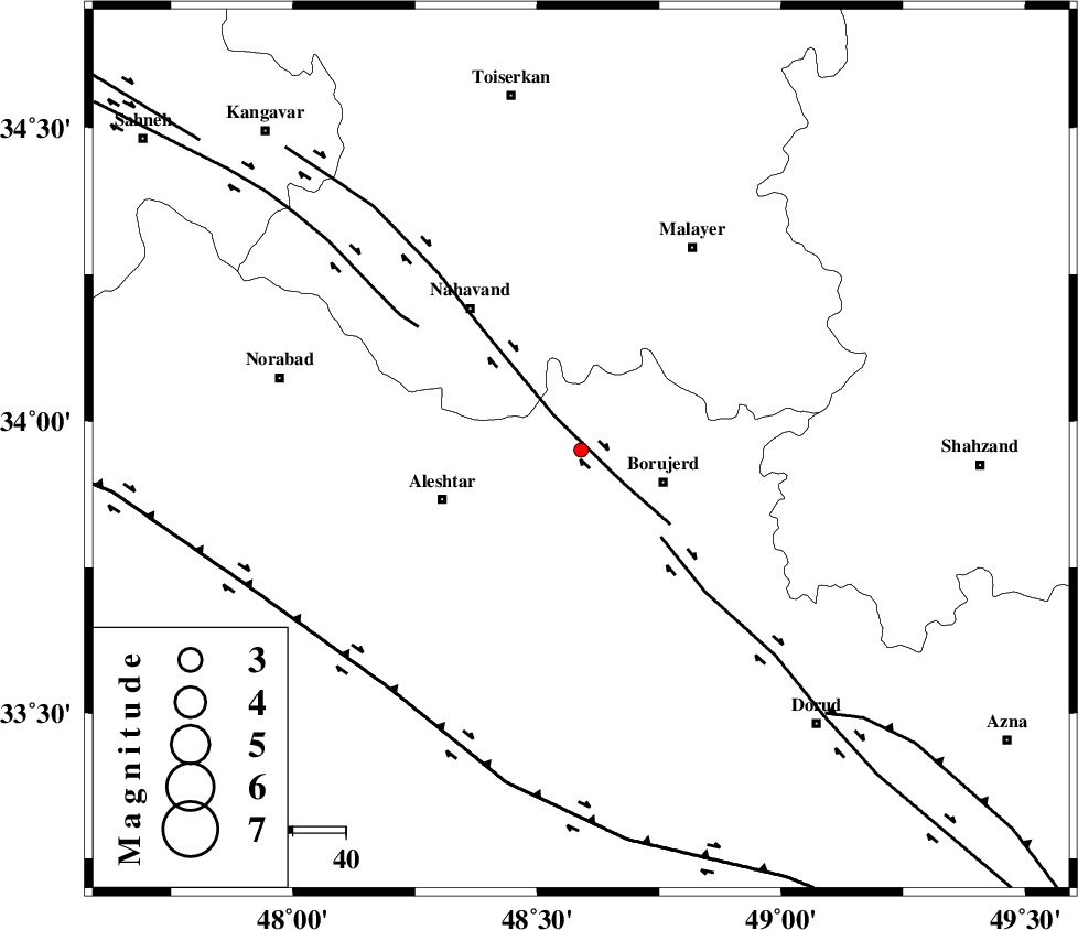
| Location | Lat:33.95 Lon: 48.59 |
| Region | Lorestan Province, 17 km West of Borujerd |
Nearest Cities |
|
| 7 km of Bon dizeh, Lorestan Province | |
| 9 km of Ashtarinan, Lorestan Province | |
| 13 km South of Jaefarabad, Lorestan Province | |
| 16 km West of Darre-ye gorg, Lorestan Province | |
| 17 km North West of Borujerd, Lorestan Province | |
| Depth | 18 km |
| Agency | |
Faults within 150 km: |
|
| NAHAVAND_F (Length: 102 km) , Distance to epicenter: 8 km | |
| DORUD (Length: 100 km) , Distance to epicenter: 22 km | |
| SAHANEH_F (Length: 77 km) , Distance to epicenter: 39 km | |
| Number of Phases | 5 |
| RMS | 0.1 |
| Number of Stations | 3 |
| Error in Latitude | >2.4 km |
| Error in Longitude | 4.2 km |
| Error in Depth | 10.3 km |
Download waveform in seisan format
to download seisan software Click here
to access information about IIEES stations Click here
Amplitude | ||||||||
| UID | Agency | Station | Component | Amplitude | Period | Arrival Time | Proccessing Time | Signal Clip |
| 83820 | IIEES | KHMZ | E | 23.5 | 0.32 | 2012-05-31 01:29:44 | 2012-05-31 02:47:00 | n |
| 83821 | IIEES | KHMZ | N | 30.4 | 0.36 | 2012-05-31 01:29:46 | 2012-05-31 02:47:00 | n |
| 83822 | IIEES | ASAO | E | 20.8 | 0.44 | 2012-05-31 01:29:47 | 2012-05-31 02:47:00 | n |
| 83823 | IIEES | SNGE | E | 14.2 | 0.28 | 2012-05-31 01:29:59 | 2012-05-31 02:47:00 | n |
| 83824 | IIEES | SNGE | N | 16.9 | 0.28 | 2012-05-31 01:29:59 | 2012-05-31 02:47:00 | n |
Phase | ||||||||||||
| Agency | Station | Component | Phase Type | Phase Quality | First Motion | Observed Arrival Time | Time Residual | Loc. Flag | Input Weight | Distance | Azimuth | |
| IIEES | KHMZ | Z | Pg | E | 2012-05-31 01:29:25 | -0.05 | y | 130 | 100 | |||
| IIEES | KHMZ | N | Sg | E | 2012-05-31 01:29:41 | 0.01 | y | 130 | 100 | |||
| IIEES | ASAO | Z | Pg | E | 2012-05-31 01:29:28 | 0.11 | y | 148 | 63 | |||
| IIEES | ASAO | E | Sg | E | 2012-05-31 01:29:46 | -0.06 | y | 148 | 63 | |||
| IIEES | SNGE | Z | Pn | E | 2012-05-31 01:29:32 | -0.02 | y | 170 | 318 | |||