
Magnitude |
:2.8 |
| Date & Time (UTC) | 2012-05-25 12:27:46.3 |
| Date & Time (Local) | 1391/3/5 16:57:46.3 |
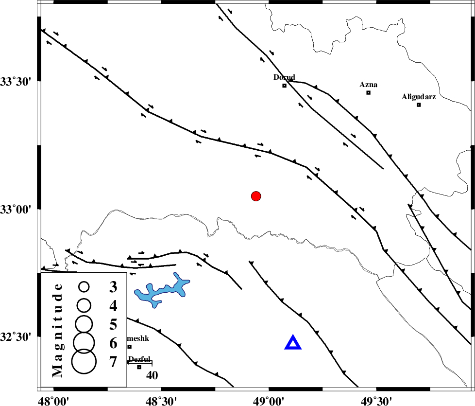
| Location | Lat:33.05 Lon: 48.94 |
| Region | Lorestan Province, 49 km South-West of Dorud |
Nearest Cities |
|
| 1 km North of Bargsar, Lorestan Province | |
| 19 km South East of Chamsangar, Lorestan Province | |
| 25 km South of Sartang barzeh, Lorestan Province | |
| 27 km South West of Shulabad, Lorestan Province | |
| 31 km North East of Shuy, Khoozestan Province | |
| Depth | 14 km |
| Agency | |
Faults within 150 km: |
|
| HZF4 (Length: 492 km) , Distance to epicenter: 20 km | |
| MFF2 (Length: 205 km) , Distance to epicenter: 28 km | |
| BALARUD_F_Z2 (Length: 58 km) , Distance to epicenter: 36 km | |
| Number of Phases | 6 |
| RMS | 0 |
| Number of Stations | 4 |
| Error in Latitude | >0.8 km |
| Error in Longitude | 1.7 km |
| Error in Depth | 2.9 km |
Download waveform in seisan format
to download seisan software Click here
to access information about IIEES stations Click here
Amplitude | ||||||||
| UID | Agency | Station | Component | Amplitude | Period | Arrival Time | Proccessing Time | Signal Clip |
| 83764 | IIEES | SHGR | E | 306.1 | 0.56 | 2012-05-25 12:28:21 | 2012-05-25 01:20:00 | n |
| 83765 | IIEES | SHGR | N | 311.2 | 0.64 | 2012-05-25 12:28:25 | 2012-05-25 01:20:00 | n |
Phase | ||||||||||||
| Agency | Station | Component | Phase Type | Phase Quality | First Motion | Observed Arrival Time | Time Residual | Loc. Flag | Input Weight | Distance | Azimuth | |
| IIEES | SHGR | Z | Pg | E | 2012-05-25 12:28:04 | 0 | y | 105 | 187 | |||
| IIEES | SHGR | E | Sg | E | 2012-05-25 12:28:17 | -0.01 | y | 105 | 187 | |||
| IIEES | KHMZ | Z | Pg | E | 2012-05-25 12:28:06 | -0.06 | y | 122 | 51 | |||
| IIEES | ASAO | Z | Pn | E | 2012-05-25 12:28:18 | 0.07 | y | 194 | 31 | |||
| IIEES | SNGE | Z | Pn | E | 2012-05-25 12:28:27 | 0.04 | y | 270 | 327 | |||
| IIEES | SNGE | E | Sg | E | 2012-05-25 12:29:02 | -0.04 | y | 270 | 327 | |||