
Magnitude |
:2.5 |
| Date & Time (UTC) | 2012-04-10 05:04:10.7 |
| Date & Time (Local) | 1391/1/22 09:34:10.7 |
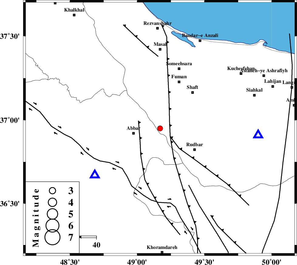
| Location | Lat:36.95 Lon: 49.17 |
| Region | Gilan Province, 18 km East of Abbar |
Nearest Cities |
|
| 12 km South of Siyahmargi, Gilan Province | |
| 14 km South of Qaleh rudkhan, Gilan Province | |
| 18 km South of Rudkhan, Gilan Province | |
| 18 km North East of Abbar, Zanjan Province | |
| 21 km North East of Void, Zanjan Province | |
| Depth | 14 km |
| Agency | |
Faults within 150 km: |
|
| RUDBAR_F (Length: 93 km) , Distance to epicenter: 8 km | |
| MASULEL_F (Length: 90 km) , Distance to epicenter: 14 km | |
| LAHIJAN_F (Length: 92 km) , Distance to epicenter: 25 km | |
| Number of Phases | 5 |
| RMS | 0.2 |
| Number of Stations | 4 |
| Error in Latitude | >4.3 km |
| Error in Longitude | 5.5 km |
| Error in Depth | 9.9 km |
Download waveform in seisan format
to download seisan software Click here
to access information about IIEES stations Click here
Amplitude | ||||||||
| UID | Agency | Station | Component | Amplitude | Period | Arrival Time | Proccessing Time | Signal Clip |
| 82699 | IIEES | THKV | E | 46.5 | 0.23 | 2012-04-10 05:05:13 | 2012-04-10 05:23:00 | n |
| 82700 | IIEES | GRMI | E | 29.8 | 0.21 | 2012-04-10 05:05:18 | 2012-04-10 05:23:00 | n |
Phase | ||||||||||||
| Agency | Station | Component | Phase Type | Phase Quality | First Motion | Observed Arrival Time | Time Residual | Loc. Flag | Input Weight | Distance | Azimuth | |
| IIEES | THKV | Z | Pg | E | 2012-04-10 05:04:42 | -0.35 | y | 192 | 126 | |||
| IIEES | CHTH | Z | Pn | E | 2012-04-10 05:04:44 | -0.16 | y | 211 | 123 | |||
| IIEES | CHTH | N | Sg | E | 2012-04-10 05:05:11 | 0.32 | y | 211 | 123 | |||
| IIEES | GRMI | Z | P | E | 2012-04-10 05:04:47 | 0.11 | y | 234 | 332 | |||
| IIEES | SNGE | Z | Pn | E | 2012-04-10 05:04:51 | 0.08 | y | 264 | 219 | |||