
Magnitude |
:2.8 |
| Date & Time (UTC) | 2012-03-22 23:59:36.7 |
| Date & Time (Local) | 1391/1/4 04:29:36.7 |
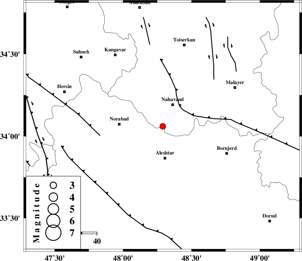
| Location | Lat:34.06 Lon: 48.29 |
| Region | Hamedan Province, 16 km South of Nahavand |
Nearest Cities |
|
| 14 km South of Gian, Hamedan Province | |
| 16 km South of Nahavand, Hamedan Province | |
| 16 km West of Babaqasem, Hamedan Province | |
| 18 km South of Barzul, Hamedan Province | |
| 20 km South of Dehghul, Hamedan Province | |
| Depth | 14 km |
| Agency | |
Faults within 150 km: |
|
| SAHANEH_F (Length: 77 km) , Distance to epicenter: 12 km | |
| NAHAVAND_F (Length: 102 km) , Distance to epicenter: 14 km | |
| DORUD (Length: 100 km) , Distance to epicenter: 51 km | |
| Number of Phases | 5 |
| RMS | 0.3 |
| Number of Stations | 4 |
| Error in Latitude | >5.4 km |
| Error in Longitude | 4.4 km |
| Error in Depth | 8.2 km |
Download waveform in seisan format
to download seisan software Click here
to access information about IIEES stations Click here
Amplitude | ||||||||
| UID | Agency | Station | Component | Amplitude | Period | Arrival Time | Proccessing Time | Signal Clip |
| 82487 | IIEES | SNGE | N | 140.2 | 0.36 | 2012-03-23 00:00:26 | 2012-03-22 11:31:00 | n |
| 82488 | IIEES | SNGE | E | 121.5 | 0.52 | 2012-03-23 00:00:27 | 2012-03-22 11:31:00 | n |
| 82489 | IIEES | KHMZ | E | 110.6 | 0.6 | 2012-03-23 00:00:32 | 2012-03-22 11:31:00 | n |
| 82490 | IIEES | KHMZ | N | 166.2 | 0.44 | 2012-03-23 00:00:34 | 2012-03-22 11:31:00 | n |
| 82491 | IIEES | ASAO | E | 121.4 | 0.54 | 2012-03-23 00:00:37 | 2012-03-22 11:31:00 | n |
| 82492 | IIEES | ASAO | N | 120.6 | 0.68 | 2012-03-23 00:00:38 | 2012-03-22 11:31:00 | n |
Phase | ||||||||||||
| Agency | Station | Component | Phase Type | Phase Quality | First Motion | Observed Arrival Time | Time Residual | Loc. Flag | Input Weight | Distance | Azimuth | |
| IIEES | SNGE | Z | Pg | E | 2012-03-23 00:00:00 | 0.09 | y | 143 | 323 | |||
| IIEES | KHMZ | Z | Pg | E | 2012-03-23 00:00:02 | -0.56 | y | 159 | 103 | |||
| IIEES | KHMZ | N | Sg | E | 2012-03-23 00:00:22 | 0.33 | y | 159 | 103 | |||
| IIEES | ASAO | Z | Pn | E | 2012-03-23 00:00:05 | 0.06 | y | 169 | 71 | |||
| IIEES | SHGR | Z | Pn | E | 2012-03-23 00:00:11 | 0.08 | y | 222 | 167 | |||