
Magnitude |
:2.6 |
| Date & Time (UTC) | 2012-03-03 00:32:50.2 |
| Date & Time (Local) | 1390/12/13 04:02:50.2 |
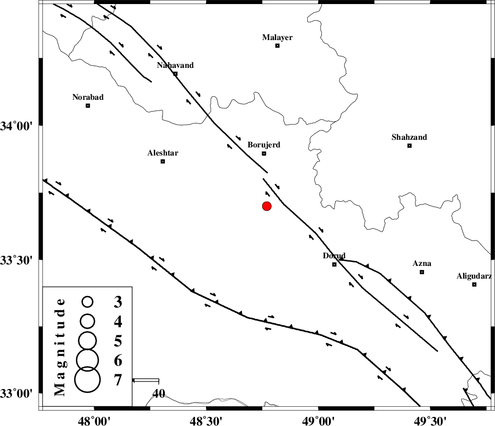
| Location | Lat:33.7 Lon: 48.77 |
| Region | Lorestan Province, 21 km South of Borujerd |
Nearest Cities |
|
| 12 km North West of Chalanchulan, Lorestan Province | |
| 14 km East of Pellekan-e sofla, Lorestan Province | |
| 15 km South of Hemmatabad, Lorestan Province | |
| 18 km North West of Razan, Lorestan Province | |
| 19 km South of Valanjerd, Lorestan Province | |
| Depth | 38 km |
| Agency | |
Faults within 150 km: |
|
| DORUD (Length: 100 km) , Distance to epicenter: 7 km | |
| NAHAVAND_F (Length: 102 km) , Distance to epicenter: 14 km | |
| MAIN_ZAGROS_R_F (Length: 1106 km) , Distance to epicenter: 37 km | |
| Number of Phases | 8 |
| RMS | 0.2 |
| Number of Stations | 4 |
| Error in Latitude | >1.4 km |
| Error in Longitude | 2.1 km |
| Error in Depth | 4 km |
Download waveform in seisan format
to download seisan software Click here
to access information about IIEES stations Click here
Amplitude | ||||||||
| UID | Agency | Station | Component | Amplitude | Period | Arrival Time | Proccessing Time | Signal Clip |
| 82141 | IIEES | ASAO | N | 79.3 | 0.4 | 2012-03-03 00:33:41 | 2012-03-02 11:47:00 | n |
| 82142 | IIEES | SHGR | E | 80.8 | 0.56 | 2012-03-03 00:33:42 | 2012-03-02 11:47:00 | n |
| 82143 | IIEES | SHGR | N | 82.9 | 0.6 | 2012-03-03 00:33:43 | 2012-03-02 11:47:00 | n |
| 82144 | IIEES | SNGE | E | 39.8 | 0.4 | 2012-03-03 00:33:50 | 2012-03-02 11:47:00 | n |
| 82145 | IIEES | SNGE | N | 65.8 | 0.4 | 2012-03-03 00:33:50 | 2012-03-02 11:47:00 | n |
Phase | ||||||||||||
| Agency | Station | Component | Phase Type | Phase Quality | First Motion | Observed Arrival Time | Time Residual | Loc. Flag | Input Weight | Distance | Azimuth | |
| IIEES | KHMZ | Z | Pg | E | 2012-03-03 00:33:08 | -0.42 | y | 111 | 88 | |||
| IIEES | KHMZ | N | Sg | E | 2012-03-03 00:33:23 | 0.04 | y | 111 | 88 | |||
| IIEES | ASAO | Z | Pg | E | 2012-03-03 00:33:14 | -0.04 | y | 149 | 51 | |||
| IIEES | ASAO | E | Sg | E | 2012-03-03 00:33:33 | 0.27 | y | 149 | 51 | |||
| IIEES | SHGR | Z | Pn | E | 2012-03-03 00:33:17 | -0.06 | y | 177 | 179 | |||
| IIEES | SHGR | N | Sg | E | 2012-03-03 00:33:40 | 0.17 | y | 177 | 179 | |||
| IIEES | SNGE | Z | Pn | E | 2012-03-03 00:33:20 | 0.1 | y | 202 | 320 | |||
| IIEES | SNGE | N | Sg | E | 2012-03-03 00:33:46 | -0.05 | y | 202 | 320 | |||