
Magnitude |
:2.7 |
| Date & Time (UTC) | 2012-02-07 18:55:46.1 |
| Date & Time (Local) | 1390/11/18 22:25:46.1 |
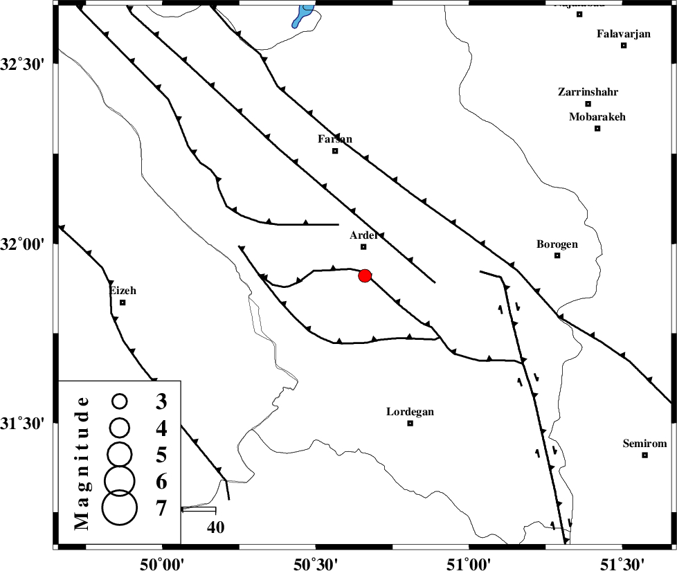
| Location | Lat:31.91 Lon: 50.66 |
| Region | Chaharmahal Bakhtiari Province, 9 km Ardel |
Nearest Cities |
|
| 5 km of Dupelan, Chaharmahal Bakhtiari Province | |
| 8 km of Naghan, Chaharmahal Bakhtiari Province | |
| 9 km of Ardel, Chaharmahal Bakhtiari Province | |
| 20 km South West of Shalamzar, Chaharmahal Bakhtiari Province | |
| 21 km North East of Sarkhun, Chaharmahal Bakhtiari Province | |
| Depth | 14 km |
| Agency | |
Faults within 150 km: |
|
| DOPOLAN_F (Length: 107 km) , Distance to epicenter: 1 km | |
| ZARDKUH_F (Length: 139 km) , Distance to epicenter: 18 km | |
| SABZKUH_F (Length: 67 km) , Distance to epicenter: 20 km | |
| Number of Phases | 5 |
| RMS | 0.1 |
| Number of Stations | 4 |
| Error in Latitude | >2.6 km |
| Error in Longitude | 4.6 km |
| Error in Depth | 7.6 km |
Download waveform in seisan format
to download seisan software Click here
to access information about IIEES stations Click here
Amplitude | ||||||||
| UID | Agency | Station | Component | Amplitude | Period | Arrival Time | Proccessing Time | Signal Clip |
| 81799 | IIEES | SHGR | E | 94.9 | 0.44 | 2012-02-07 18:56:43 | 2012-02-07 06:07:00 | n |
| 81800 | IIEES | SHGR | N | 129.4 | 0.44 | 2012-02-07 18:56:45 | 2012-02-07 06:07:00 | n |
| 81801 | IIEES | KHMZ | E | 48.4 | 0.4 | 2012-02-07 18:56:54 | 2012-02-07 06:07:00 | n |
Phase | ||||||||||||
| Agency | Station | Component | Phase Type | Phase Quality | First Motion | Observed Arrival Time | Time Residual | Loc. Flag | Input Weight | Distance | Azimuth | |
| IIEES | SHGR | Z | Pg | E | 2012-02-07 18:56:15 | -0.05 | y | 177 | 278 | |||
| IIEES | KHMZ | Z | Pn | E | 2012-02-07 18:56:20 | 0.12 | y | 213 | 342 | |||
| IIEES | KHMZ | N | Sg | E | 2012-02-07 18:56:46 | -0.11 | y | 213 | 342 | |||
| IIEES | NASN | Z | Pn | E | 2012-02-07 18:56:21 | -0.15 | y | 225 | 63 | |||
| IIEES | GHVR | Z | Pn | E | 2012-02-07 18:56:30 | 0.2 | y | 290 | 11 | |||