
Magnitude |
:2.7 |
| Date & Time (UTC) | 2012-02-01 17:33:58.8 |
| Date & Time (Local) | 1390/11/12 21:03:58.8 |
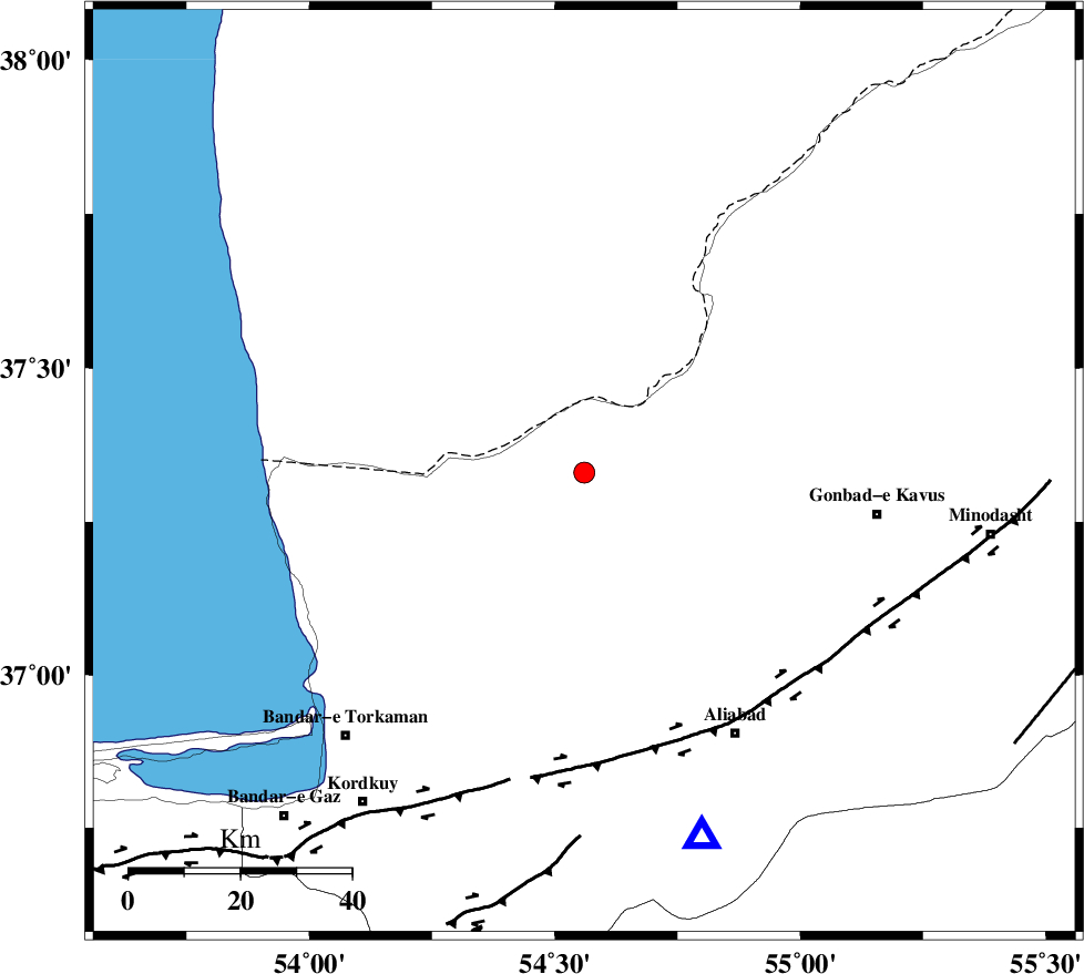
| Location | Lat:37.33 Lon: 54.56 |
| Region | Golestan Province, 36 km North-East of Aq Qaleh |
Nearest Cities |
|
| 20 km South West of Enchehborun, Golestan Province | |
| 31 km North West of Gariduji, Golestan Province | |
| 36 km North of Qanqarmeh, Golestan Province | |
| 37 km North East of Aq Qaleh, Golestan Province | |
| 40 km North of Nodeh malek, Golestan Province | |
| Depth | 18 km |
| Agency | |
Faults within 150 km: |
|
| KHAZAR_F (Length: 523 km) , Distance to epicenter: 51 km | |
| N_ALBORZ_F (Length: 360 km) , Distance to epicenter: 81 km | |
| SHAVAR_F (Length: 87 km) , Distance to epicenter: 83 km | |
| Number of Phases | 5 |
| RMS | 0.1 |
| Number of Stations | 4 |
| Error in Latitude | >2.2 km |
| Error in Longitude | 3 km |
| Error in Depth | 5.8 km |
Download waveform in seisan format
to download seisan software Click here
to access information about IIEES stations Click here
Amplitude | ||||||||
| UID | Agency | Station | Component | Amplitude | Period | Arrival Time | Proccessing Time | Signal Clip |
| 81694 | IIEES | MRVT | N | 126.9 | 0.32 | 2012-02-01 17:34:44 | 2012-02-01 04:56:00 | n |
Phase | ||||||||||||
| Agency | Station | Component | Phase Type | Phase Quality | First Motion | Observed Arrival Time | Time Residual | Loc. Flag | Input Weight | Distance | Azimuth | |
| IIEES | SHRO | Z | Pn | E | 2012-02-01 17:34:30 | -0.13 | y | 195 | 138 | |||
| IIEES | SHRO | E | Sg | E | 2012-02-01 17:34:54 | 0.06 | y | 195 | 138 | |||
| IIEES | BJRD | Z | Pn | E | 2012-02-01 17:34:37 | 0.13 | y | 255 | 80 | |||
| IIEES | BJRD | E | Sg | E | 2012-02-01 17:35:10 | -0.06 | y | 255 | 80 | |||
| IIEES | CHTH | Z | Pn | E | 2012-02-01 17:34:49 | 0 | y | 345 | 244 | |||