
Magnitude |
:4 |
| Date & Time (UTC) | 2012-01-22 09:44:51.2 |
| Date & Time (Local) | 1390/11/2 13:14:51.2 |
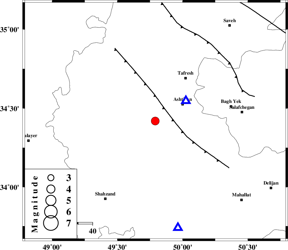
| Location | Lat:34.42 Lon: 49.79 |
| Region | Markazi Province, 23 km South-West of Ashtiyan |
Nearest Cities |
|
| 14 km East of Farmahin, Markazi Province | |
| 16 km North of Davoodabad, Markazi Province | |
| 20 km North of Ebakabad, Markazi Province | |
| 22 km South West of Shahrab, Markazi Province | |
| 23 km South West of Ashtiyan, Markazi Province | |
| Depth | 12 km |
| Agency | |
Faults within 150 km: |
|
| TAFRESH_F (Length: 117 km) , Distance to epicenter: 11 km | |
| INDES_F (Length: 98 km) , Distance to epicenter: 64 km | |
| KUSHK_E_NOSRAT_F (Length: 230 km) , Distance to epicenter: 93 km | |
| Number of Phases | 5 |
| RMS | 0.1 |
| Number of Stations | 4 |
| Error in Latitude | >2.2 km |
| Error in Longitude | 8.7 km |
| Error in Depth | 4.3 km |
Download waveform in seisan format
to download seisan software Click here
to access information about IIEES stations Click here
Amplitude | ||||||||
| UID | Agency | Station | Component | Amplitude | Period | Arrival Time | Proccessing Time | Signal Clip |
| 81534 | IIEES | GHVR | N | 3053.7 | 0.4 | 2012-01-22 09:45:30 | 2012-01-22 09:01:00 | n |
| 81535 | IIEES | GHVR | E | 5428.6 | 0.44 | 2012-01-22 09:45:30 | 2012-01-22 09:01:00 | n |
| 81536 | IIEES | THKV | N | 1277.1 | 0.28 | 2012-01-22 09:45:49 | 2012-01-22 09:01:00 | n |
| 81537 | IIEES | THKV | E | 1291.8 | 0.88 | 2012-01-22 09:45:52 | 2012-01-22 09:01:00 | n |
Phase | ||||||||||||
| Agency | Station | Component | Phase Type | Phase Quality | First Motion | Observed Arrival Time | Time Residual | Loc. Flag | Input Weight | Distance | Azimuth | |
| IIEES | ASAO | Z | Pg | E | 2012-01-22 09:44:56 | -0.06 | y | 26.3 | 56 | |||
| IIEES | ASAO | E | Sg | E | 2012-01-22 09:45:00 | 0.12 | y | 26.3 | 56 | |||
| IIEES | THKV | Z | Pn | E | 2012-01-22 09:45:23 | 0.16 | y | 194 | 31 | |||
| IIEES | THKV | E | Sg | E | 2012-01-22 09:45:48 | -0.14 | y | 194 | 31 | |||
| IIEES | NASN | Z | Pn | E | 2012-01-22 09:45:40 | -0.09 | y | 333 | 122 | |||