
Magnitude |
:3.3 |
| Date & Time (UTC) | 2012-01-01 14:44:03.6 |
| Date & Time (Local) | 1390/10/11 18:14:03.6 |
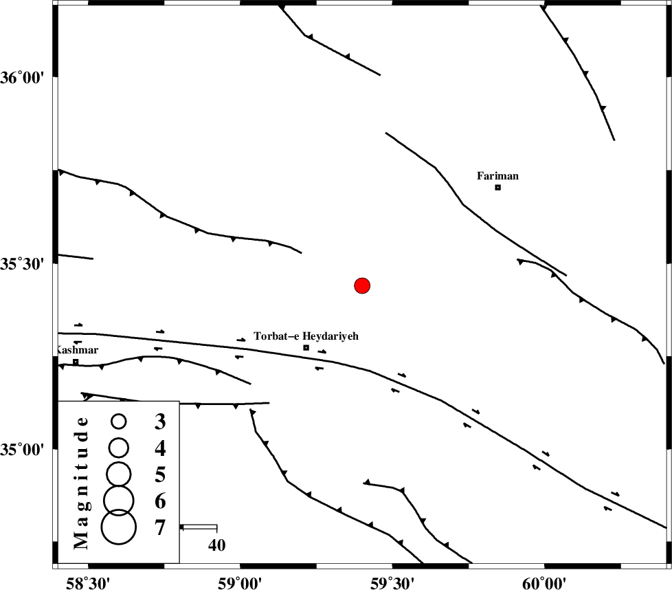
| Location | Lat:35.44 Lon: 59.4 |
| Region | Khorasan(center) Province, 25 km North-East of Torbat-e heydariyeh |
Nearest Cities |
|
| 10 km of Nasr, Khorasan(center) Province | |
| 15 km North of Karizak-e nagahani, Khorasan(center) Province | |
| 21 km North East of Manzar, Khorasan(center) Province | |
| 22 km South East of Rebatsang, Khorasan(center) Province | |
| 25 km South East of Sarhang, Khorasan(center) Province | |
| Depth | 18 km |
| Agency | |
Faults within 150 km: |
|
| BALHAR_F (Length: 117 km) , Distance to epicenter: 20 km | |
| DORUNEH_F (Length: 713 km) , Distance to epicenter: 24 km | |
| TORBAT_E_JAM_F1 (Length: 71 km) , Distance to epicenter: 39 km | |
| Number of Phases | 5 |
| RMS | 0 |
| Number of Stations | 3 |
| Error in Latitude | >4.1 km |
| Error in Longitude | 2.3 km |
| Error in Depth | 6.9 km |
Download waveform in seisan format
to download seisan software Click here
to access information about IIEES stations Click here
Amplitude | ||||||||
| UID | Agency | Station | Component | Amplitude | Period | Arrival Time | Proccessing Time | Signal Clip |
| 81219 | IIEES | SHRT | N | 427.7 | 0.48 | 2012-01-01 14:45:10 | 2012-01-01 02:05:00 | n |
| 81220 | IIEES | SHRT | E | 423.5 | 0.4 | 2012-01-01 14:45:11 | 2012-01-01 02:05:00 | n |
| 81221 | IIEES | TABS | E | 128.9 | 0.48 | 2012-01-01 14:45:34 | 2012-01-01 02:05:00 | n |
| 81222 | IIEES | TABS | N | 197.7 | 0.4 | 2012-01-01 14:45:35 | 2012-01-01 02:05:00 | n |
| 81223 | IIEES | SHRO | E | 24.1 | 0.68 | 2012-01-01 14:45:58 | 2012-01-01 02:05:00 | n |
Phase | ||||||||||||
| Agency | Station | Component | Phase Type | Phase Quality | First Motion | Observed Arrival Time | Time Residual | Loc. Flag | Input Weight | Distance | Azimuth | |
| IIEES | SHRT | Z | Pn | E | 2012-01-01 14:44:37 | -0.05 | y | 215 | 157 | |||
| IIEES | SHRT | E | Sg | E | 2012-01-01 14:45:04 | 0.04 | y | 215 | 157 | |||
| IIEES | TABS | Z | Pn | E | 2012-01-01 14:44:46 | -0.03 | y | 289 | 227 | |||
| IIEES | TABS | N | Sg | E | 2012-01-01 14:45:24 | 0 | y | 289 | 227 | |||
| IIEES | SHRO | Z | Pn | E | 2012-01-01 14:44:49 | 0.05 | y | 313 | 283 | |||