
Magnitude |
:2.8 |
| Date & Time (UTC) | 2011-12-30 01:04:06.6 |
| Date & Time (Local) | 1390/10/9 04:34:06.6 |
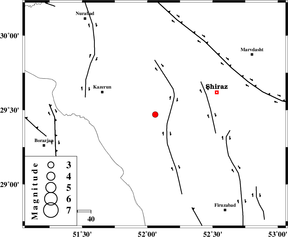
| Location | Lat:29.47 Lon: 52.06 |
| Region | Fars Province, 42 km South-East of Kazerun |
Nearest Cities |
|
| 10 km West of Richi, Fars Province | |
| 23 km South East of Kalani, Fars Province | |
| 24 km North East of Baladeh, Fars Province | |
| 25 km North East of Dadin-e olia, Fars Province | |
| 27 km South West of Khanehzanian, Fars Province | |
| Depth | 41 km |
| Agency | |
Faults within 150 km: |
|
| KAREBASS_F (Length: 98 km) , Distance to epicenter: 11 km | |
| SABZ_PUSHAN_F_Z3 (Length: 37 km) , Distance to epicenter: 41 km | |
| KAZERUN_F (Length: 96 km) , Distance to epicenter: 53 km | |
| Number of Phases | 5 |
| RMS | 0.2 |
| Number of Stations | 3 |
| Error in Latitude | >3.1 km |
| Error in Longitude | 3.7 km |
| Error in Depth | 5.7 km |
Download waveform in seisan format
to download seisan software Click here
to access information about IIEES stations Click here
Amplitude | ||||||||
| UID | Agency | Station | Component | Amplitude | Period | Arrival Time | Proccessing Time | Signal Clip |
| 81209 | IIEES | AHRM | N | 309.8 | 0.36 | 2011-12-30 01:04:40 | 2011-12-30 12:55:00 | n |
| 81210 | IIEES | AHRM | E | 420.2 | 0.4 | 2011-12-30 01:04:40 | 2011-12-30 12:55:00 | n |
| 81211 | IIEES | GHIR | N | 89.4 | 0.68 | 2011-12-30 01:04:58 | 2011-12-30 12:55:00 | n |
| 81212 | IIEES | GHIR | E | 109.8 | 0.36 | 2011-12-30 01:05:00 | 2011-12-30 12:55:00 | n |
Phase | ||||||||||||
| Agency | Station | Component | Phase Type | Phase Quality | First Motion | Observed Arrival Time | Time Residual | Loc. Flag | Input Weight | Distance | Azimuth | |
| IIEES | AHRM | Z | Pg | E | 2011-12-30 01:04:23 | 0.05 | y | 100 | 228 | |||
| IIEES | GHIR | Z | Pn | E | 2011-12-30 01:04:31 | -0.03 | y | 160 | 145 | |||
| IIEES | GHIR | N | Sg | E | 2011-12-30 01:04:52 | 0.04 | y | 160 | 145 | |||
| IIEES | NASN | Z | Pn | E | 2011-12-30 01:04:58 | -0.29 | y | 376 | 11 | |||
| IIEES | NASN | E | Sn | 2011-12-30 01:05:37 | 0.22 | y | 376 | 11 | ||||