
Magnitude |
:3.2 |
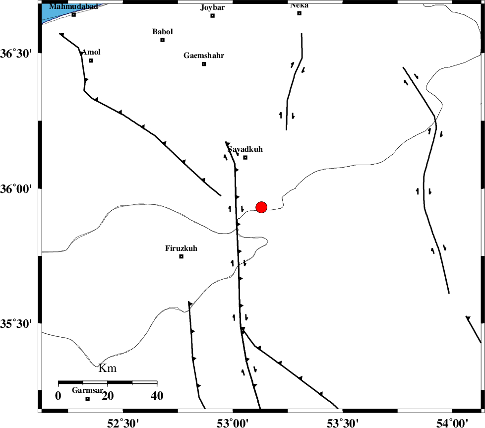
| Date & Time (UTC) | 2011-12-09 18:08:55.8 |
| Date & Time (Local) | 1390/9/18 21:38:55.8 |
| Location | Lat:35.93 Lon: 53.13 |
| Region | Mazandaran Province, 22 km South of Pol-E-Sefid |
Nearest Cities |
|
| 13 km North West of Chashem, Semnan Province | |
| 18 km South of Sangdeh, Mazandaran Province | |
| 19 km South of Shurmast-e peyrudbar, Mazandaran Province | |
| 21 km South of Pol-E-Sefid, Mazandaran Province | |
| 23 km South East of Elahband, Mazandaran Province | |
| Depth | 18 km |
| Agency | |
Faults within 150 km: |
|
| ATARI_F (Length: 185 km) , Distance to epicenter: 26 km | |
| N_ALBORZ_F (Length: 360 km) , Distance to epicenter: 31 km | |
| MOSHA_F (Length: 234 km) , Distance to epicenter: 51 km | |
| Number of Phases | 7 |
| RMS | 0.1 |
| Number of Stations | 7 |
| Error in Latitude | >3.3 km |
| Error in Longitude | 1.7 km |
| Error in Depth | 3.2 km |
Download waveform in seisan format
to download seisan software Click here
to access information about IIEES stations Click here
Amplitude | ||||||||
| UID | Agency | Station | Component | Amplitude | Period | Arrival Time | Proccessing Time | Signal Clip |
| 80948 | IIEES | THKV | E | 181.1 | 0.6 | 2011-12-09 18:10:05 | 2011-12-09 05:31:00 | n |
| 80949 | IIEES | GHVR | N | 84.9 | 0.36 | 2011-12-09 18:10:09 | 2011-12-09 05:31:00 | n |
| 80950 | IIEES | GHVR | E | 342.1 | 0.52 | 2011-12-09 18:10:10 | 2011-12-09 05:31:00 | n |
Phase | ||||||||||||
| Agency | Station | Component | Phase Type | Phase Quality | First Motion | Observed Arrival Time | Time Residual | Loc. Flag | Input Weight | Distance | Azimuth | |
| IIEES | SHRO | Z | Pn | E | 2011-12-09 18:09:35 | -0.1 | y | 260 | 87 | |||
| IIEES | SHRO | E | Sg | E | 2011-12-09 18:10:09 | 0.1 | y | 260 | 87 | |||
| IIEES | ASAO | Z | Pn | E | 2011-12-09 18:09:43 | 0.01 | y | 321 | 243 | |||
| IIEES | ASAO | N | Sg | E | 2011-12-09 18:10:26 | -0.02 | y | 321 | 243 | |||
| IIEES | MRVT | Z | P | E | 2011-12-09 18:09:43 | -0.04 | y | 327 | 53 | |||
| IIEES | NASN | Z | P | E | 2011-12-09 18:09:46 | -0.11 | y | 348 | 185 | |||
| IIEES | KHMZ | Z | Pn | E | 2011-12-09 18:09:50 | 0.19 | y | 378 | 231 | |||