
Magnitude |
:2.8 |
| Date & Time (UTC) | 2011-10-29 17:27:32.6 |
| Date & Time (Local) | 1390/8/7 20:57:32.6 |
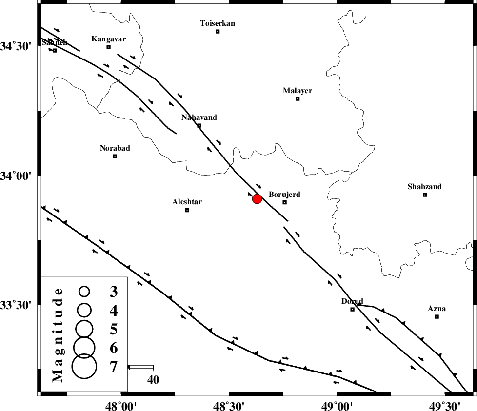
| Location | Lat:33.91 Lon: 48.63 |
| Region | Lorestan Province, 12 km West of Borujerd |
Nearest Cities |
|
| 6 km of Bon dizeh, Lorestan Province | |
| 12 km South of Ashtarinan, Lorestan Province | |
| 12 km North West of Borujerd, Lorestan Province | |
| 16 km North of Pellekan-e sofla, Lorestan Province | |
| 17 km South of Darre-ye gorg, Lorestan Province | |
| Depth | 18 km |
| Agency | |
Faults within 150 km: |
|
| NAHAVAND_F (Length: 102 km) , Distance to epicenter: 5 km | |
| DORUD (Length: 100 km) , Distance to epicenter: 17 km | |
| SAHANEH_F (Length: 77 km) , Distance to epicenter: 44 km | |
| Number of Phases | 4 |
| RMS | 0 |
| Number of Stations | 5 |
| Error in Latitude | >5.9 km |
| Error in Longitude | 3 km |
| Error in Depth | 22.4 km |
Download waveform in seisan format
to download seisan software Click here
to access information about IIEES stations Click here
Amplitude | ||||||||
| UID | Agency | Station | Component | Amplitude | Period | Arrival Time | Proccessing Time | Signal Clip |
| 80563 | IIEES | ASAO | N | 125.3 | 0.56 | 2011-10-29 17:28:17 | 2011-10-29 05:50:00 | n |
| 80564 | IIEES | SNGE | N | 90 | 0.39 | 2011-10-29 17:28:27 | 2011-10-29 05:50:00 | n |
| 80565 | IIEES | SHGR | N | 118.7 | 0.55 | 2011-10-29 17:28:37 | 2011-10-29 05:50:00 | n |
| 80566 | IIEES | SHGR | E | 95.8 | 0.12 | 2011-10-29 17:28:39 | 2011-10-29 05:50:00 | n |
| 80567 | IIEES | GHVR | E | 48.1 | 0.21 | 2011-10-29 17:28:54 | 2011-10-29 05:50:00 | n |
Phase | ||||||||||||
| Agency | Station | Component | Phase Type | Phase Quality | First Motion | Observed Arrival Time | Time Residual | Loc. Flag | Input Weight | Distance | Azimuth | |
| IIEES | KHMZ | Z | Pg | E | 2011-10-29 17:27:54 | -0.02 | y | 125 | 98 | |||
| IIEES | ASAO | Z | Pg | E | 2011-10-29 17:27:57 | -0.03 | y | 147 | 61 | |||
| IIEES | SNGE | Z | Pg | E | 2011-10-29 17:28:02 | 0 | y | 176 | 318 | |||
| IIEES | GHVR | Z | Pg | E | 2011-10-29 17:28:13 | 0.04 | y | 249 | 75 | |||