
Magnitude |
:3.1 |
| Date & Time (UTC) | 2011-10-24 06:56:11.6 |
| Date & Time (Local) | 1390/8/2 10:26:11.6 |
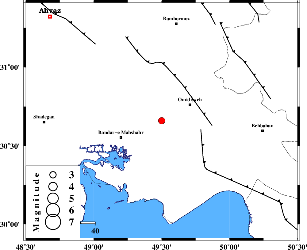
| Location | Lat:30.66 Lon: 49.5 |
| Region | Khoozestan Province, 24 km South-West of Omidiyeh |
Nearest Cities |
|
| 18 km South of Abdoliyeh, Khoozestan Province | |
| 23 km South West of Omidiyeh, Khoozestan Province | |
| 24 km West of Chah-e salem, Khoozestan Province | |
| 27 km South of Ramshir, Khoozestan Province | |
| 28 km North West of Chamkhalf-e eisa, Khoozestan Province | |
| Depth | 36 km |
| Agency | |
Faults within 150 km: |
|
| RAG_E_SEFID_F (Length: 84 km) , Distance to epicenter: 28 km | |
| AGHAJARI_F (Length: 88 km) , Distance to epicenter: 30 km | |
| MFF4 (Length: 62 km) , Distance to epicenter: 70 km | |
| Number of Phases | 6 |
| RMS | 0.1 |
| Number of Stations | 5 |
| Error in Latitude | >6.7 km |
| Error in Longitude | 9 km |
| Error in Depth | 6.4 km |
Download waveform in seisan format
to download seisan software Click here
to access information about IIEES stations Click here
Amplitude | ||||||||
| UID | Agency | Station | Component | Amplitude | Period | Arrival Time | Proccessing Time | Signal Clip |
| 80532 | IIEES | SHGR | N | 302.8 | 0.33 | 2011-10-24 06:57:07 | 2011-10-24 07:09:00 | n |
| 80533 | IIEES | KHMZ | E | 33.8 | 0.61 | 2011-10-24 06:57:41 | 2011-10-24 07:09:00 | n |
Phase | ||||||||||||
| Agency | Station | Component | Phase Type | Phase Quality | First Motion | Observed Arrival Time | Time Residual | Loc. Flag | Input Weight | Distance | Azimuth | |
| IIEES | SHGR | Z | Pg | E | 2011-10-24 06:56:39 | 0.01 | y | 174 | 338 | |||
| IIEES | SHGR | N | Sg | E | 2011-10-24 06:57:00 | -0.01 | y | 174 | 338 | |||
| IIEES | KHMZ | Z | Pn | E | 2011-10-24 06:57:00 | -0.15 | y | 345 | 7 | |||
| IIEES | NASN | Z | Pn | E | 2011-10-24 06:57:06 | -0.04 | y | 394 | 52 | |||
| IIEES | ASAO | Z | Pn | E | 2011-10-24 06:57:11 | 0.1 | y | 435 | 6 | |||
| IIEES | GHVR | Z | Pn | E | 2011-10-24 06:57:13 | 0.12 | y | 455 | 21 | |||