
Magnitude |
:2.8 |
| Date & Time (UTC) | 2011-10-07 06:16:21.1 |
| Date & Time (Local) | 1390/7/15 09:46:21.1 |
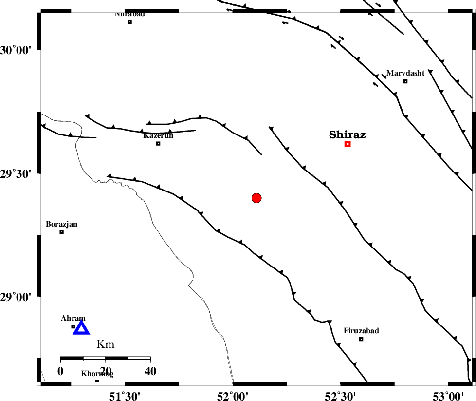
| Location | Lat:29.4 Lon: 52.11 |
| Region | Fars Province, 59 km North of Farashband |
Nearest Cities |
|
| 12 km of Richi, Fars Province | |
| 21 km North East of Baladeh, Fars Province | |
| 22 km North East of Jareh, Fars Province | |
| 26 km North East of Dadin-e olia, Fars Province | |
| 31 km South East of Kalani, Fars Province | |
| Depth | 6 km |
| Agency | |
Faults within 150 km: |
|
| KAREBASS_F (Length: 98 km) , Distance to epicenter: 4 km | |
| SABZ_PUSHAN_F_Z3 (Length: 37 km) , Distance to epicenter: 38 km | |
| SABZ_PUSHAN_F_Z1 (Length: 69 km) , Distance to epicenter: 49 km | |
| Number of Phases | 6 |
| RMS | 0.1 |
| Number of Stations | 3 |
| Error in Latitude | >3 km |
| Error in Longitude | 1.2 km |
| Error in Depth | 6.5 km |
Download waveform in seisan format
to download seisan software Click here
to access information about IIEES stations Click here
Amplitude | ||||||||
| UID | Agency | Station | Component | Amplitude | Period | Arrival Time | Proccessing Time | Signal Clip |
| 80390 | IIEES | AHRM | E | 326.2 | 0.28 | 2011-10-07 06:16:54 | 2011-10-07 06:55:00 | n |
| 80391 | IIEES | AHRM | N | 338.3 | 0.48 | 2011-10-07 06:16:54 | 2011-10-07 06:55:00 | n |
| 80392 | IIEES | GHIR | E | 145.8 | 0.4 | 2011-10-07 06:17:10 | 2011-10-07 06:55:00 | n |
Phase | ||||||||||||
| Agency | Station | Component | Phase Type | Phase Quality | First Motion | Observed Arrival Time | Time Residual | Loc. Flag | Input Weight | Distance | Azimuth | |
| IIEES | AHRM | Z | Pg | E | 2011-10-07 06:16:38 | 0.07 | y | 98.3 | 233 | |||
| IIEES | AHRM | N | Sg | E | 2011-10-07 06:16:50 | -0.04 | y | 98.3 | 233 | |||
| IIEES | GHIR | Z | Pg | E | 2011-10-07 06:16:47 | -0.06 | y | 150 | 145 | |||
| IIEES | GHIR | E | Sg | E | 2011-10-07 06:17:06 | 0.04 | y | 150 | 145 | |||
| IIEES | NASN | Z | Pn | E | 2011-10-07 06:17:17 | -0.06 | y | 383 | 10 | |||
| IIEES | NASN | N | S | E | 2011-10-07 06:17:58 | 0.04 | y | 383 | 10 | |||