
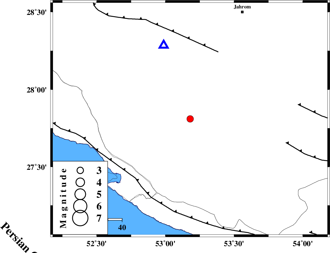
Magnitude |
:3.1 |
| Date & Time (UTC) | 2011-09-11 17:15:07.0 |
| Date & Time (Local) | 1390/6/20 21:45:07.0 |
| Location | Lat:27.81 Lon: 53.18 |
| Region | Fars Province, 53 km North of Lamerd |
Nearest Cities |
|
| 25 km West of Khonj, Fars Province | |
| 30 km North East of Alamarvdasht, Fars Province | |
| 39 km South of Seyfabad, Fars Province | |
| 41 km North East of Mehr, Fars Province | |
| 42 km North West of Fedagh, Fars Province | |
| Depth | 12 km |
| Agency | |
Faults within 150 km: |
|
| QIR_F (Length: 130 km) , Distance to epicenter: 52 km | |
| MFF3 (Length: 292 km) , Distance to epicenter: 58 km | |
| LAR_F (Length: 99 km) , Distance to epicenter: 71 km | |
| Number of Phases | 6 |
| RMS | 0.1 |
| Number of Stations | 4 |
| Error in Latitude | >4.9 km |
| Error in Longitude | 7.2 km |
| Error in Depth | 5.3 km |
Download waveform in seisan format
to download seisan software Click here
to access information about IIEES stations Click here
Amplitude | ||||||||
| UID | Agency | Station | Component | Amplitude | Period | Arrival Time | Proccessing Time | Signal Clip |
| 80222 | IIEES | GHIR | E | 1577.8 | 0.32 | 2011-09-11 17:15:33 | 2011-09-11 06:09:00 | n |
| 80223 | IIEES | BNDS | E | 56.3 | 0.48 | 2011-09-11 17:17:00 | 2011-09-11 06:09:00 | n |
Phase | ||||||||||||
| Agency | Station | Component | Phase Type | Phase Quality | First Motion | Observed Arrival Time | Time Residual | Loc. Flag | Input Weight | Distance | Azimuth | |
| IIEES | GHIR | Z | Pg | E | 2011-09-11 17:15:16 | -0.15 | y | 55.7 | 340 | |||
| IIEES | GHIR | E | Sg | E | 2011-09-11 17:15:24 | 0.08 | y | 55.7 | 340 | |||
| IIEES | BNDS | Z | P | E | 2011-09-11 17:15:52 | 0.16 | y | 299 | 98 | |||
| IIEES | BNDS | E | S | E | 2011-09-11 17:16:25 | -0.1 | y | 299 | 98 | |||
| IIEES | NASN | Z | P | E | 2011-09-11 17:16:24 | -0.01 | y | 554 | 356 | |||
| IIEES | TABS | Z | Pn | E | 2011-09-11 17:16:48 | 0.02 | y | 749 | 29 | |||