
Magnitude |
:3.1 |
| Date & Time (UTC) | 2011-09-11 15:04:09.4 |
| Date & Time (Local) | 1390/6/20 19:34:09.4 |
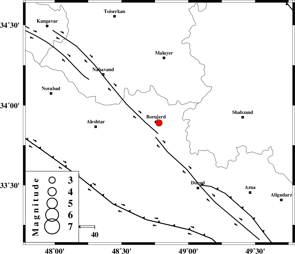
| Location | Lat:33.89 Lon: 48.78 |
| Region | Lorestan Province, 2 km Borujerd |
Nearest Cities |
|
| 2 km of Borujerd, Lorestan Province | |
| 6 km North of Valanjerd, Lorestan Province | |
| 6 km North of Hemmatabad, Lorestan Province | |
| 14 km East of Bon dizeh, Lorestan Province | |
| 18 km South East of Ashtarinan, Lorestan Province | |
| Depth | 16 km |
| Agency | |
Faults within 150 km: |
|
| NAHAVAND_F (Length: 102 km) , Distance to epicenter: 7 km | |
| DORUD (Length: 100 km) , Distance to epicenter: 10 km | |
| MAIN_ZAGROS_R_F (Length: 1106 km) , Distance to epicenter: 52 km | |
| Number of Phases | 8 |
| RMS | 0.1 |
| Number of Stations | 6 |
| Error in Latitude | >1.5 km |
| Error in Longitude | 1.9 km |
| Error in Depth | 3.9 km |
Download waveform in seisan format
to download seisan software Click here
to access information about IIEES stations Click here
Amplitude | ||||||||
| UID | Agency | Station | Component | Amplitude | Period | Arrival Time | Proccessing Time | Signal Clip |
| 80217 | IIEES | ASAO | N | 337.9 | 0.6 | 2011-09-11 15:04:54 | 2011-09-11 03:38:00 | n |
| 80218 | IIEES | ASAO | E | 267.4 | 0.56 | 2011-09-11 15:04:58 | 2011-09-11 03:38:00 | n |
| 80219 | IIEES | SNGE | N | 297 | 0.52 | 2011-09-11 15:05:11 | 2011-09-11 03:38:00 | n |
| 80220 | IIEES | GHVR | N | 88.9 | 0.64 | 2011-09-11 15:05:25 | 2011-09-11 03:38:00 | n |
| 80221 | IIEES | GHVR | E | 111.3 | 0.52 | 2011-09-11 15:05:27 | 2011-09-11 03:38:00 | n |
Phase | ||||||||||||
| Agency | Station | Component | Phase Type | Phase Quality | First Motion | Observed Arrival Time | Time Residual | Loc. Flag | Input Weight | Distance | Azimuth | |
| IIEES | ASAO | Z | Pg | E | 2011-09-11 15:04:32 | 0.01 | y | 136 | 57 | |||
| IIEES | ASAO | N | Sg | E | 2011-09-11 15:04:49 | 0.06 | y | 136 | 57 | |||
| IIEES | SNGE | Z | Pn | E | 2011-09-11 15:04:40 | -0.08 | y | 187 | 316 | |||
| IIEES | SHGR | Z | Pn | E | 2011-09-11 15:04:41 | 0.03 | y | 198 | 179 | |||
| IIEES | GHVR | Z | Pn | E | 2011-09-11 15:04:46 | -0.06 | y | 237 | 73 | |||
| IIEES | GHVR | E | Sg | E | 2011-09-11 15:05:16 | -0.07 | y | 237 | 73 | |||
| IIEES | ZNJK | Z | Pn | E | 2011-09-11 15:04:55 | 0.09 | y | 309 | 358 | |||
| IIEES | NASN | Z | Pn | E | 2011-09-11 15:05:06 | 0.05 | y | 394 | 107 | |||