
Magnitude |
:4.1 |
| Date & Time (UTC) | 2011-08-27 02:55:59.3 |
| Date & Time (Local) | 1390/6/5 07:25:59.3 |
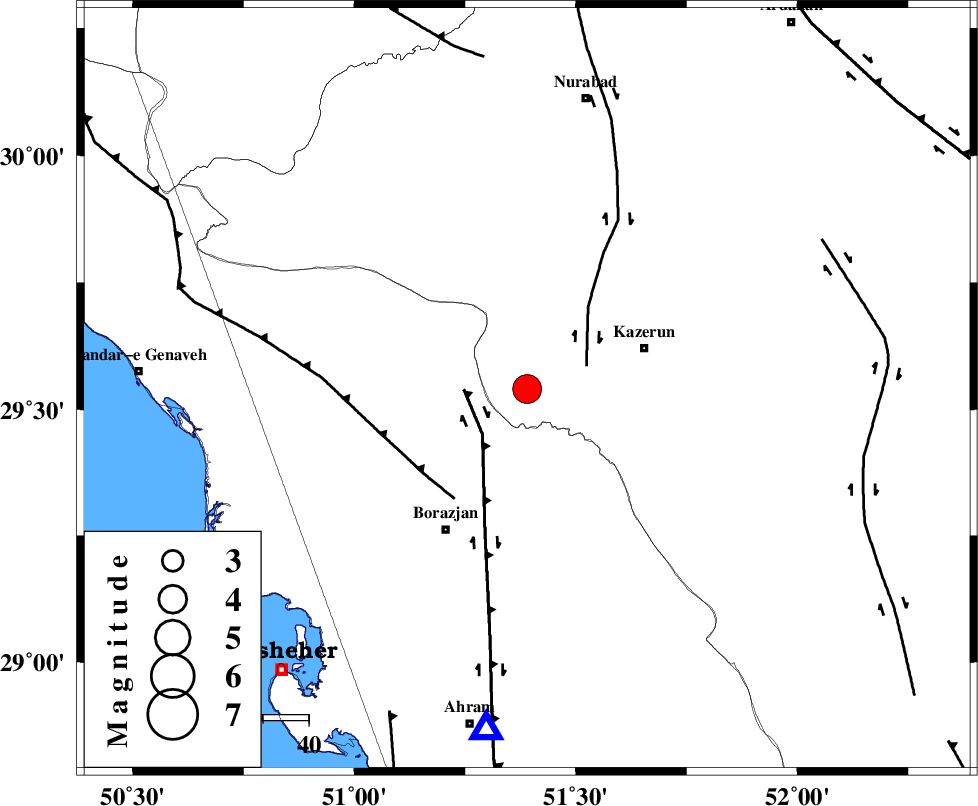
| Location | Lat:29.54 Lon: 51.39 |
| Region | Fars Province, 27 km West of Kazerun |
Nearest Cities |
|
| 6 km of Khesht, Fars Province | |
| 13 km of Kamaraj, Fars Province | |
| 15 km North of Dalki, Bushehr Province | |
| 23 km South West of Deris, Fars Province | |
| 26 km West of Mehranjan, Fars Province | |
| Depth | 14 km |
| Agency | |
Faults within 150 km: |
|
| BORAZJAN_F (Length: 168 km) , Distance to epicenter: 14 km | |
| KAZERUN_F (Length: 96 km) , Distance to epicenter: 14 km | |
| ZFF3 (Length: 125 km) , Distance to epicenter: 29 km | |
| Number of Phases | 9 |
| RMS | 0.2 |
| Number of Stations | 8 |
| Error in Latitude | >3.6 km |
| Error in Longitude | 3.4 km |
| Error in Depth | 8.3 km |
Download waveform in seisan format
to download seisan software Click here
to access information about IIEES stations Click here
Amplitude | ||||||||
| UID | Agency | Station | Component | Amplitude | Period | Arrival Time | Proccessing Time | Signal Clip |
| 80100 | IIEES | GHIR | E | 1872 | 0.4 | 2011-08-27 02:57:11 | 2011-08-27 03:22:00 | n |
| 80101 | IIEES | SHGR | E | 468 | 0.52 | 2011-08-27 02:57:59 | 2011-08-27 03:22:00 | n |
| 80102 | IIEES | SHGR | N | 294.6 | 0.44 | 2011-08-27 02:58:10 | 2011-08-27 03:22:00 | n |
| 80103 | IIEES | BNDS | N | 127.4 | 0.4 | 2011-08-27 02:58:35 | 2011-08-27 03:22:00 | n |
Phase | ||||||||||||
| Agency | Station | Component | Phase Type | Phase Quality | First Motion | Observed Arrival Time | Time Residual | Loc. Flag | Input Weight | Distance | Azimuth | |
| IIEES | AHRM | Z | Pg | E | 2011-08-27 02:56:12 | -0.13 | y | 75.1 | 187 | |||
| IIEES | GHIR | Z | Pn | E | 2011-08-27 02:56:33 | 0.48 | y | 209 | 131 | |||
| IIEES | GHIR | E | Sg | E | 2011-08-27 02:56:58 | -0.18 | y | 209 | 131 | |||
| IIEES | SHGR | N | Pn | E | 2011-08-27 02:56:53 | 0.08 | y | 377 | 320 | |||
| IIEES | NASN | Z | Pn | E | 2011-08-27 02:56:55 | -0.14 | y | 386 | 20 | |||
| IIEES | KRBR | Z | Pn | E | 2011-08-27 02:57:12 | 0.11 | y | 522 | 83 | |||
| IIEES | BNDS | Z | Pn | E | 2011-08-27 02:57:12 | -0.13 | y | 525 | 116 | |||
| IIEES | GHVR | Z | Pn | E | 2011-08-27 02:57:14 | -0.19 | y | 548 | 359 | |||
| IIEES | TABS | Z | Pn | E | 2011-08-27 02:57:35 | 0.02 | y | 709 | 49 | |||