
Magnitude |
:2.9 |
| Date & Time (UTC) | 2011-08-17 06:20:35.1 |
| Date & Time (Local) | 1390/5/26 10:50:35.1 |
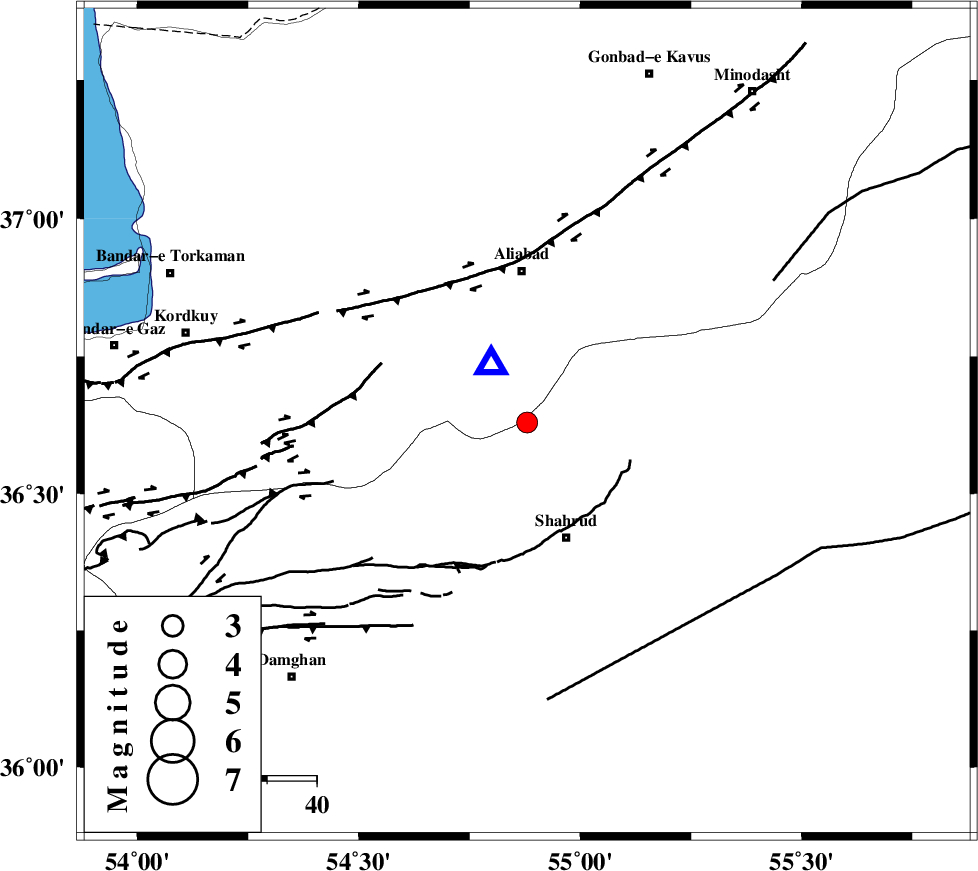
| Location | Lat:36.63 Lon: 54.88 |
| Region | Semnan Province, 31 km South of Ali Abad |
Nearest Cities |
|
| 20 km North West of Bastam, Semnan Province | |
| 20 km West of Qaleh-ye nokharqan, Semnan Province | |
| 25 km North of Shahrud, Semnan Province | |
| 27 km North East of Majen, Semnan Province | |
| 31 km South of Ali Abad, Golestan Province | |
| Depth | 14 km |
| Agency | |
Faults within 150 km: |
|
| SHAVAR_F (Length: 87 km) , Distance to epicenter: 7 km | |
| ASTANEH_F (Length: 72 km) , Distance to epicenter: 29 km | |
| DAMGHAN_F (Length: 95 km) , Distance to epicenter: 39 km | |
| Number of Phases | 4 |
| RMS | 0.1 |
| Number of Stations | 6 |
| Error in Latitude | >3.2 km |
| Error in Longitude | 5 km |
| Error in Depth | 8.9 km |
Download waveform in seisan format
to download seisan software Click here
to access information about IIEES stations Click here
Amplitude | ||||||||
| UID | Agency | Station | Component | Amplitude | Period | Arrival Time | Proccessing Time | Signal Clip |
| 80004 | IIEES | TABS | N | 21.8 | 0.5 | 2011-08-17 06:22:44 | 2011-08-17 06:49:00 | n |
| 80005 | IIEES | GHVR | N | 18.5 | 0.5 | 2011-08-17 06:22:33 | 2011-08-17 06:49:00 | n |
| 80006 | IIEES | NASN | E | 15.8 | 0.4 | 2011-08-17 06:22:47 | 2011-08-17 06:49:00 | n |
| 80007 | IIEES | NASN | N | 12.3 | 0.56 | 2011-08-17 06:22:51 | 2011-08-17 06:49:00 | n |
Phase | ||||||||||||
| Agency | Station | Component | Phase Type | Phase Quality | First Motion | Observed Arrival Time | Time Residual | Loc. Flag | Input Weight | Distance | Azimuth | |
| IIEES | SHRO | Z | Pg | E | 2011-08-17 06:20:55 | -0.15 | y | 123 | 124 | |||
| IIEES | MRVT | Z | Pg | E | 2011-08-17 06:21:01 | 0.03 | y | 157 | 43 | |||
| IIEES | CHTH | Z | Pn | E | 2011-08-17 06:21:26 | -0.05 | y | 347 | 258 | |||
| IIEES | TABS | Z | Pn | E | 2011-08-17 06:21:31 | 0.2 | y | 388 | 148 | |||