
Magnitude |
:2.7 |
| Date & Time (UTC) | 2011-08-11 08:20:15.8 |
| Date & Time (Local) | 1390/5/20 12:50:15.8 |
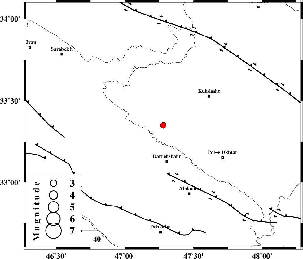
| Location | Lat:33.35 Lon: 47.28 |
| Region | Lorestan Province, 25 km North of Darreh Shahr |
Nearest Cities |
|
| 8 km of Kunani, Lorestan Province | |
| 14 km South of Garab, Lorestan Province | |
| 15 km North West of Suri, Lorestan Province | |
| 19 km North West of Chaqabol, Lorestan Province | |
| 21 km North of Dashtabad-e olia, Ilam Province | |
| Depth | 14 km |
| Agency | |
Faults within 150 km: |
|
| BALARUD_F_Z1 (Length: 87 km) , Distance to epicenter: 33 km | |
| MFF6 (Length: 144 km) , Distance to epicenter: 64 km | |
| HZF4 (Length: 492 km) , Distance to epicenter: 67 km | |
| Number of Phases | 6 |
| RMS | 0.4 |
| Number of Stations | 4 |
| Error in Latitude | >4.1 km |
| Error in Longitude | 6.4 km |
| Error in Depth | 9 km |
Download waveform in seisan format
to download seisan software Click here
to access information about IIEES stations Click here
Amplitude | ||||||||
| UID | Agency | Station | Component | Amplitude | Period | Arrival Time | Proccessing Time | Signal Clip |
| 79958 | IIEES | SNGE | N | 68.2 | 0.49 | 2011-08-11 08:21:15 | 2011-08-11 08:41:00 | n |
| 79959 | IIEES | SNGE | E | 66.7 | 0.55 | 2011-08-11 08:21:17 | 2011-08-11 08:41:00 | n |
| 79960 | IIEES | SHGR | N | 82.2 | 0.48 | 2011-08-11 08:21:27 | 2011-08-11 08:41:00 | n |
Phase | ||||||||||||
| Agency | Station | Component | Phase Type | Phase Quality | First Motion | Observed Arrival Time | Time Residual | Loc. Flag | Input Weight | Distance | Azimuth | |
| IIEES | SNGE | Z | Pg | E | 2011-08-11 08:20:47 | -0.42 | y | 193 | 2 | |||
| IIEES | SNGE | N | Sg | E | 2011-08-11 08:21:11 | 0.19 | y | 193 | 2 | |||
| IIEES | SHGR | Z | Pg | E | 2011-08-11 08:20:48 | 0 | y | 199 | 134 | |||
| IIEES | KHMZ | Z | Pn | E | 2011-08-11 08:20:54 | -0.26 | y | 253 | 80 | |||
| IIEES | KHMZ | N | Sg | E | 2011-08-11 08:21:27 | -0.16 | y | 253 | 80 | |||
| IIEES | GHVR | Z | Pn | E | 2011-08-11 08:21:12 | 0.8 | y | 387 | 70 | |||