
Magnitude |
:2.5 |
| Date & Time (UTC) | 2011-07-31 04:41:04.3 |
| Date & Time (Local) | 1390/5/9 09:11:04.3 |
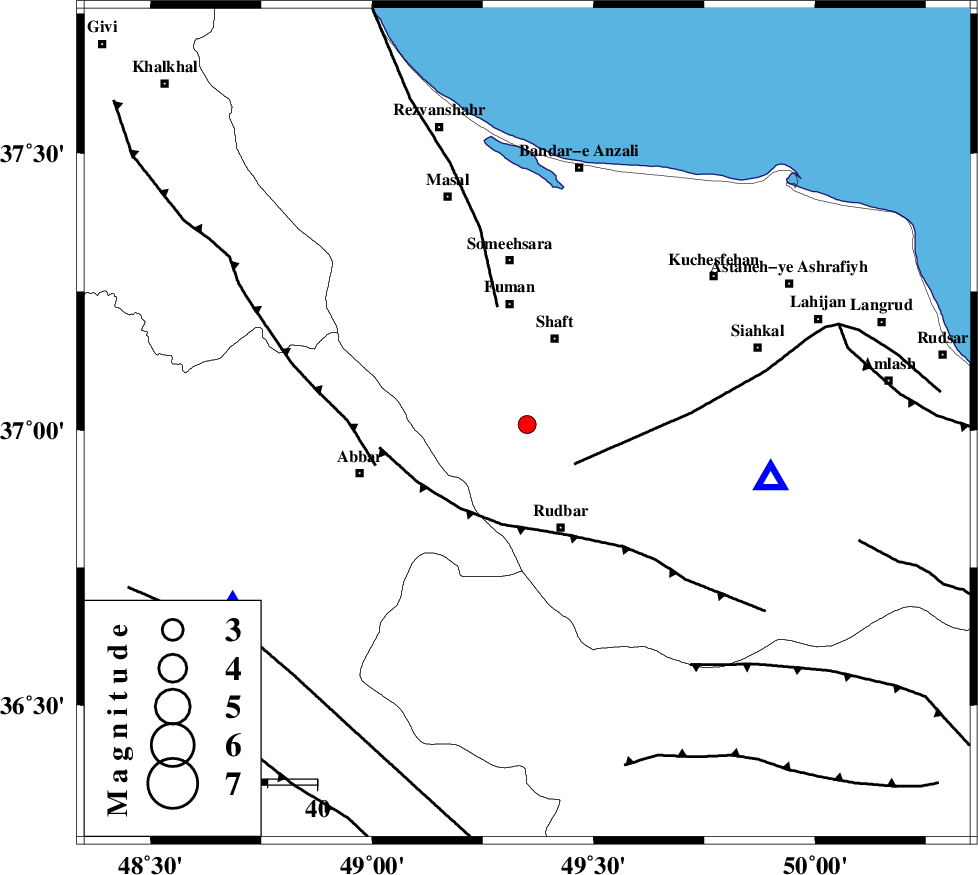
| Location | Lat:37.01 Lon: 49.35 |
| Region | Gilan Province, 18 km South of Shaft |
Nearest Cities |
|
| 13 km East of Siyahmargi, Gilan Province | |
| 13 km South of Gorabpas, Gilan Province | |
| 14 km North West of Nasir mahalleh, Gilan Province | |
| 16 km South of Chobareh, Gilan Province | |
| 18 km South of Shaft, Gilan Province | |
| Depth | 15 km |
| Agency | |
Faults within 150 km: |
|
| LAHIJAN_F (Length: 92 km) , Distance to epicenter: 12 km | |
| RUDBAR_F (Length: 93 km) , Distance to epicenter: 21 km | |
| TALESH_F (Length: 258 km) , Distance to epicenter: 24 km | |
| Number of Phases | 6 |
| RMS | 0.2 |
| Number of Stations | 5 |
| Error in Latitude | >10.3 km |
| Error in Longitude | 5 km |
| Error in Depth | 6.7 km |
Download waveform in seisan format
to download seisan software Click here
to access information about IIEES stations Click here
Amplitude | ||||||||
| UID | Agency | Station | Component | Amplitude | Period | Arrival Time | Proccessing Time | Signal Clip |
| 79865 | IIEES | ZNJK | N | 224.1 | 0.08 | 2011-07-31 04:41:29 | 2011-07-31 05:07:00 | n |
| 79866 | IIEES | GHVR | E | 14.2 | 0.24 | 2011-07-31 04:42:30 | 2011-07-31 05:07:00 | n |
| 79867 | IIEES | GHVR | N | 13.9 | 0.42 | 2011-07-31 04:42:37 | 2011-07-31 05:07:00 | n |
Phase | ||||||||||||
| Agency | Station | Component | Phase Type | Phase Quality | First Motion | Observed Arrival Time | Time Residual | Loc. Flag | Input Weight | Distance | Azimuth | |
| IIEES | ZNJK | Z | Pg | E | 2011-07-31 04:41:16 | 0.12 | y | 70 | 238 | |||
| IIEES | ZNJK | N | Sg | E | 2011-07-31 04:41:25 | -0.17 | y | 70 | 238 | |||
| IIEES | SNGE | Z | Pn | E | 2011-07-31 04:41:46 | 0.11 | y | 279 | 221 | |||
| IIEES | DAMV | Z | Pn | E | 2011-07-31 04:41:46 | -0.28 | y | 281 | 122 | |||
| IIEES | GHVR | Z | P | E | 2011-07-31 04:41:53 | 0.23 | y | 329 | 148 | |||
| IIEES | KHMZ | Z | P | E | 2011-07-31 04:41:57 | 0.01 | y | 367 | 171 | |||