
Magnitude |
:2.9 |
| Date & Time (UTC) | 2011-07-25 00:24:48.1 |
| Date & Time (Local) | 1390/5/3 04:54:48.1 |
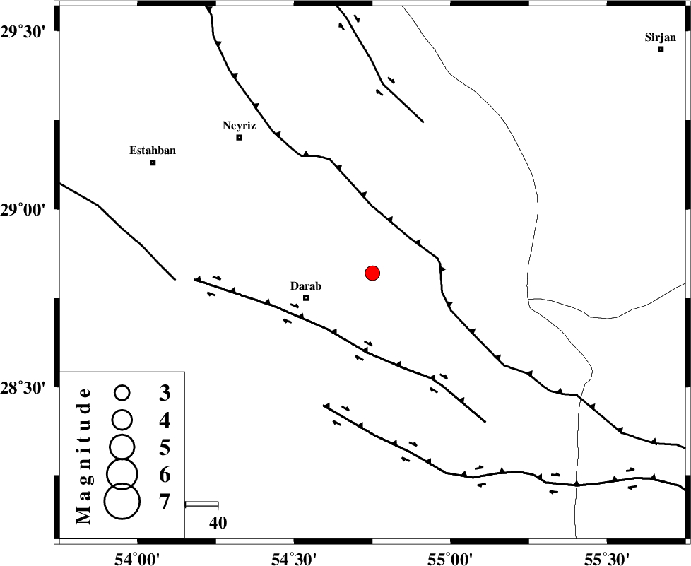
| Location | Lat:28.82 Lon: 54.75 |
| Region | Fars Province, 22 km East of Darab |
Nearest Cities |
|
| 20 km North of Dehkheyr, Fars Province | |
| 21 km North East of Sang-e charak, Fars Province | |
| 22 km North East of Darab, Fars Province | |
| 24 km North East of Shahnan, Fars Province | |
| 36 km South of Qataruyeh, Fars Province | |
| Depth | 15 km |
| Agency | |
Faults within 150 km: |
|
| MAIN_ZAGROS_R_F (Length: 1106 km) , Distance to epicenter: 16 km | |
| HZF1 (Length: 102 km) , Distance to epicenter: 22 km | |
| HZF2 (Length: 437 km) , Distance to epicenter: 44 km | |
| Number of Phases | 5 |
| RMS | 0 |
| Number of Stations | 3 |
| Error in Latitude | >1.2 km |
| Error in Longitude | 1.3 km |
| Error in Depth | 3 km |
Download waveform in seisan format
to download seisan software Click here
to access information about IIEES stations Click here
Amplitude | ||||||||
| UID | Agency | Station | Component | Amplitude | Period | Arrival Time | Proccessing Time | Signal Clip |
| 79793 | IIEES | BNDS | N | 76.4 | 0.6 | 2011-07-25 00:25:54 | 2011-07-25 12:44:00 | n |
| 79794 | IIEES | KRBR | N | 74.7 | 0.6 | 2011-07-25 00:25:59 | 2011-07-25 12:44:00 | n |
| 79795 | IIEES | KRBR | E | 90.5 | 0.56 | 2011-07-25 00:26:00 | 2011-07-25 12:44:00 | n |
Phase | ||||||||||||
| Agency | Station | Component | Phase Type | Phase Quality | First Motion | Observed Arrival Time | Time Residual | Loc. Flag | Input Weight | Distance | Azimuth | |
| IIEES | GHIR | Z | Pg | E | 2011-07-25 00:25:18 | 0 | y | 182 | 252 | |||
| IIEES | BNDS | Z | Pn | E | 2011-07-25 00:25:21 | -0.07 | y | 210 | 138 | |||
| IIEES | BNDS | E | Sg | E | 2011-07-25 00:25:47 | 0.03 | y | 210 | 138 | |||
| IIEES | KRBR | Z | Pn | E | 2011-07-25 00:25:25 | 0.07 | y | 234 | 56 | |||
| IIEES | KRBR | E | Sg | E | 2011-07-25 00:25:54 | -0.03 | y | 234 | 56 | |||