
Magnitude |
:2.5 |
| Date & Time (UTC) | 2011-07-20 22:52:04.0 |
| Date & Time (Local) | 1390/4/30 03:22:04.0 |
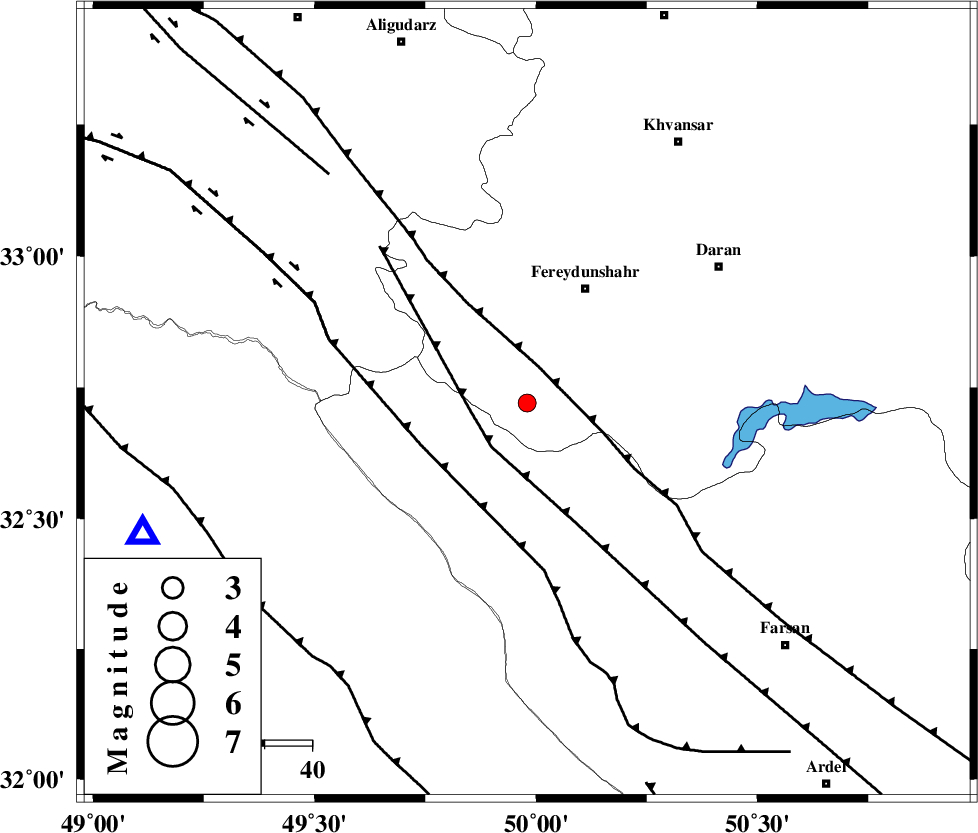
| Location | Lat:32.72 Lon: 49.98 |
| Region | Esfahan Province, 27 km South-West of Fereydunshahr |
Nearest Cities |
|
| 11 km North East of Durak, Chaharmahal Bakhtiari Province | |
| 18 km South East of Masir, Esfahan Province | |
| 20 km South of Sibak, Esfahan Province | |
| 23 km West of Ghale? sorkh, Esfahan Province | |
| 27 km South West of Fereydunshahr, Esfahan Province | |
| Depth | 7 km |
| Agency | |
Faults within 150 km: |
|
| MAIN_ZAGROS_R_F (Length: 1106 km) , Distance to epicenter: 8 km | |
| ARDAL_F (Length: 170 km) , Distance to epicenter: 12 km | |
| ZARDKUH_F (Length: 139 km) , Distance to epicenter: 24 km | |
| Number of Phases | 6 |
| RMS | 0.1 |
| Number of Stations | 4 |
| Error in Latitude | >2.7 km |
| Error in Longitude | 5.5 km |
| Error in Depth | 5 km |
Download waveform in seisan format
to download seisan software Click here
to access information about IIEES stations Click here
Amplitude | ||||||||
| UID | Agency | Station | Component | Amplitude | Period | Arrival Time | Proccessing Time | Signal Clip |
| 79709 | IIEES | SHGR | N | 191.4 | 0.44 | 2011-07-20 22:52:44 | 2011-07-20 11:05:00 | n |
| 79710 | IIEES | SHGR | E | 112.3 | 0.64 | 2011-07-20 22:52:46 | 2011-07-20 11:05:00 | n |
| 79711 | IIEES | ASAO | E | 26.9 | 0.4 | 2011-07-20 22:53:08 | 2011-07-20 11:05:00 | n |
| 79712 | IIEES | ASAO | N | 22.7 | 0.28 | 2011-07-20 22:53:09 | 2011-07-20 11:05:00 | n |
Phase | ||||||||||||
| Agency | Station | Component | Phase Type | Phase Quality | First Motion | Observed Arrival Time | Time Residual | Loc. Flag | Input Weight | Distance | Azimuth | |
| IIEES | KHMZ | Z | Pg | E | 2011-07-20 22:52:23 | -0.12 | y | 113 | 359 | |||
| IIEES | KHMZ | E | Sg | E | 2011-07-20 22:52:38 | 0.1 | y | 113 | 359 | |||
| IIEES | SHGR | Z | Pg | E | 2011-07-20 22:52:26 | -0.03 | y | 130 | 239 | |||
| IIEES | SHGR | E | Sg | E | 2011-07-20 22:52:42 | 0.05 | y | 130 | 239 | |||
| IIEES | ASAO | Z | Pn | E | 2011-07-20 22:52:37 | -0.15 | y | 203 | 1 | |||
| IIEES | GHVR | Z | Pn | E | 2011-07-20 22:52:41 | 0.15 | y | 228 | 31 | |||