
Magnitude |
:3.5 |
| Date & Time (UTC) | 2011-07-14 20:56:51.0 |
| Date & Time (Local) | 1390/4/24 01:26:51.0 |
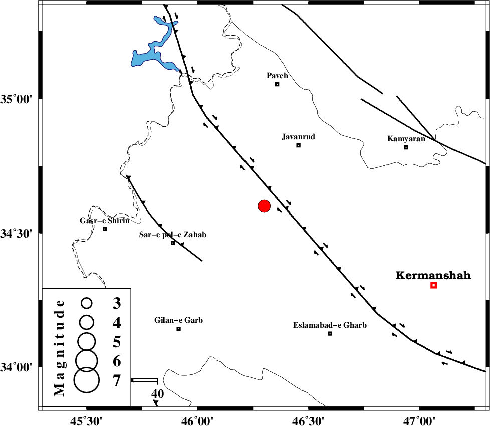
| Location | Lat:34.6 Lon: 46.3 |
| Region | Kermanshah Province, 29 km South-West of Javanrud |
Nearest Cities |
|
| 9 km of Mirabad, Kermanshah Province | |
| 11 km North of Zavleh olia, Kermanshah Province | |
| 18 km West of Dolatabad, Kermanshah Province | |
| 19 km South East of Qolqoleh, Kermanshah Province | |
| 22 km South West of Sarukhan, Kermanshah Province | |
| Depth | 7 km |
| Agency | |
Faults within 150 km: |
|
| HZF4 (Length: 492 km) , Distance to epicenter: 10 km | |
| MFF8 (Length: 48 km) , Distance to epicenter: 34 km | |
| SARTAKHT_F (Length: 78 km) , Distance to epicenter: 60 km | |
| Number of Phases | 5 |
| RMS | 0.2 |
| Number of Stations | 6 |
| Error in Latitude | >5.3 km |
| Error in Longitude | 5.5 km |
| Error in Depth | 4.1 km |
Download waveform in seisan format
to download seisan software Click here
to access information about IIEES stations Click here
Amplitude | ||||||||
| UID | Agency | Station | Component | Amplitude | Period | Arrival Time | Proccessing Time | Signal Clip |
| 79689 | IIEES | SNGE | N | 1335.1 | 0.36 | 2011-07-14 20:57:27 | 2011-07-14 09:51:00 | n |
| 79690 | IIEES | SNGE | E | 1609.6 | 0.48 | 2011-07-14 20:57:29 | 2011-07-14 09:51:00 | n |
| 79691 | IIEES | KHMZ | N | 106.2 | 0.56 | 2011-07-14 20:58:45 | 2011-07-14 09:51:00 | n |
| 79692 | IIEES | KHMZ | E | 92.6 | 0.56 | 2011-07-14 20:58:45 | 2011-07-14 09:51:00 | n |
Phase | ||||||||||||
| Agency | Station | Component | Phase Type | Phase Quality | First Motion | Observed Arrival Time | Time Residual | Loc. Flag | Input Weight | Distance | Azimuth | |
| IIEES | SNGE | N | Sg | E | 2011-07-14 20:57:24 | 0 | y | 110 | 60 | |||
| IIEES | ZNJK | Z | Pn | E | 2011-07-14 20:57:38 | 0 | y | 316 | 43 | |||
| IIEES | ASAO | Z | Pn | E | 2011-07-14 20:57:42 | 0.22 | y | 342 | 90 | |||
| IIEES | THKV | E | Sn | 2011-07-14 20:58:41 | 0 | y | 442 | 69 | ||||
| IIEES | GHVR | Z | Pn | E | 2011-07-14 20:57:55 | -0.27 | y | 454 | 90 | |||