
Magnitude |
:3.2 |
| Date & Time (UTC) | 2011-07-13 10:48:53.2 |
| Date & Time (Local) | 1390/4/22 15:18:53.2 |
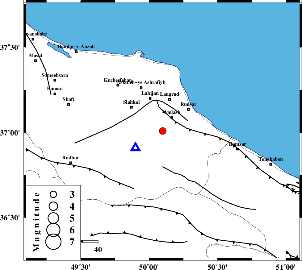
| Location | Lat:37.01 Lon: 50.1 |
| Region | Gilan Province, 10 km Amlash |
Nearest Cities |
|
| 11 km of Amlash, Gilan Province | |
| 12 km West of Sanjus, Gilan Province | |
| 13 km South of Chinijan, Gilan Province | |
| 13 km East of Khorma, Gilan Province | |
| 18 km West of Kalachay, Gilan Province | |
| Depth | 18 km |
| Agency | |
Faults within 150 km: |
|
| KHAZAR_F (Length: 523 km) , Distance to epicenter: 10 km | |
| LAHIJAN_F (Length: 92 km) , Distance to epicenter: 16 km | |
| BONAN_F (Length: 74 km) , Distance to epicenter: 23 km | |
| Number of Phases | 6 |
| RMS | 0.4 |
| Number of Stations | 5 |
| Error in Latitude | >22.8 km |
| Error in Longitude | 7 km |
| Error in Depth | 8.9 km |
Download waveform in seisan format
to download seisan software Click here
to access information about IIEES stations Click here
Amplitude | ||||||||
| UID | Agency | Station | Component | Amplitude | Period | Arrival Time | Proccessing Time | Signal Clip |
| 79686 | IIEES | ZNJK | E | 418.9 | 0.13 | 2011-07-13 10:49:32 | 2011-07-13 11:10:00 | n |
| 79687 | IIEES | ZNJK | N | 393.4 | 0.09 | 2011-07-13 10:49:32 | 2011-07-13 11:10:00 | n |
| 79688 | IIEES | THKV | E | 519.6 | 0.26 | 2011-07-13 10:49:35 | 2011-07-13 11:10:00 | n |
Phase | ||||||||||||
| Agency | Station | Component | Phase Type | Phase Quality | First Motion | Observed Arrival Time | Time Residual | Loc. Flag | Input Weight | Distance | Azimuth | |
| IIEES | ZNJK | Z | Pg | E | 2011-07-13 10:49:15 | -0.06 | y | 132 | 254 | |||
| IIEES | ZNJK | N | Sg | E | 2011-07-13 10:49:31 | 0.09 | y | 132 | 254 | |||
| IIEES | THKV | Z | Pg | E | 2011-07-13 10:49:17 | 0.35 | y | 140 | 150 | |||
| IIEES | CHTH | Z | Pg | E | 2011-07-13 10:49:18 | -0.39 | y | 153 | 143 | |||
| IIEES | ASAO | Z | Pn | E | 2011-07-13 10:49:34 | -0.54 | y | 273 | 182 | |||
| IIEES | GHVR | Z | Pn | E | 2011-07-13 10:49:38 | 0.57 | y | 299 | 159 | |||