
Magnitude |
:3.7 |
| Date & Time (UTC) | 2011-07-01 12:29:30.2 |
| Date & Time (Local) | 1390/4/10 16:59:30.2 |
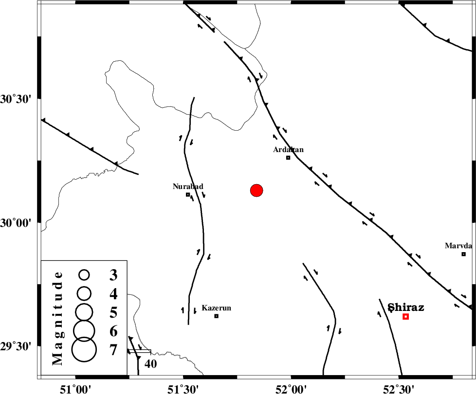
| Location | Lat:30.13 Lon: 51.84 |
| Region | Fars Province, 20 km South-West of Ardakan |
Nearest Cities |
|
| 20 km West of Bahrghan, Fars Province | |
| 20 km South West of Ardakan, Fars Province | |
| 30 km North East of Gachgaran, Fars Province | |
| 31 km North East of Nurabad, Fars Province | |
| 34 km South East of Masiri, Fars Province | |
| Depth | 46 km |
| Agency | |
Faults within 150 km: |
|
| HZF3 (Length: 197 km) , Distance to epicenter: 23 km | |
| KAZERUN_F (Length: 96 km) , Distance to epicenter: 26 km | |
| KAREBASS_F (Length: 98 km) , Distance to epicenter: 39 km | |
| Number of Phases | 6 |
| RMS | 0.3 |
| Number of Stations | 6 |
| Error in Latitude | >7.9 km |
| Error in Longitude | 8.7 km |
| Error in Depth | 15.3 km |
Download waveform in seisan format
to download seisan software Click here
to access information about IIEES stations Click here
Amplitude | ||||||||
| UID | Agency | Station | Component | Amplitude | Period | Arrival Time | Proccessing Time | Signal Clip |
| 79483 | IIEES | AHRM | N | 1025.3 | 0.17 | 2011-07-01 12:30:19 | 2011-07-01 12:59:00 | n |
| 79484 | IIEES | GHIR | N | 386.5 | 0.54 | 2011-07-01 12:30:47 | 2011-07-01 12:59:00 | n |
| 79485 | IIEES | SHGR | E | 286.3 | 0.95 | 2011-07-01 12:31:12 | 2011-07-01 12:59:00 | n |
Phase | ||||||||||||
| Agency | Station | Component | Phase Type | Phase Quality | First Motion | Observed Arrival Time | Time Residual | Loc. Flag | Input Weight | Distance | Azimuth | |
| IIEES | AHRM | Z | Pg | E | 2011-07-01 12:29:54 | -0.1 | y | 150 | 201 | |||
| IIEES | GHIR | Z | Pg | E | 2011-07-01 12:30:07 | -0.1 | y | 232 | 151 | |||
| IIEES | GHIR | N | Sg | E | 2011-07-01 12:30:35 | 0.2 | y | 232 | 151 | |||
| IIEES | NASN | Z | Pn | E | 2011-07-01 12:30:14 | 0.3 | y | 310 | 17 | |||
| IIEES | KRBR | N | Pn | E | 2011-07-01 12:30:33 | -0.5 | y | 474 | 91 | |||
| IIEES | BNDS | Z | Pn | E | 2011-07-01 12:30:39 | 0.2 | y | 519 | 125 | |||