
Magnitude |
:3.9 |
| Date & Time (UTC) | 2011-05-12 05:37:45.4 |
| Date & Time (Local) | 1390/2/22 10:07:45.4 |
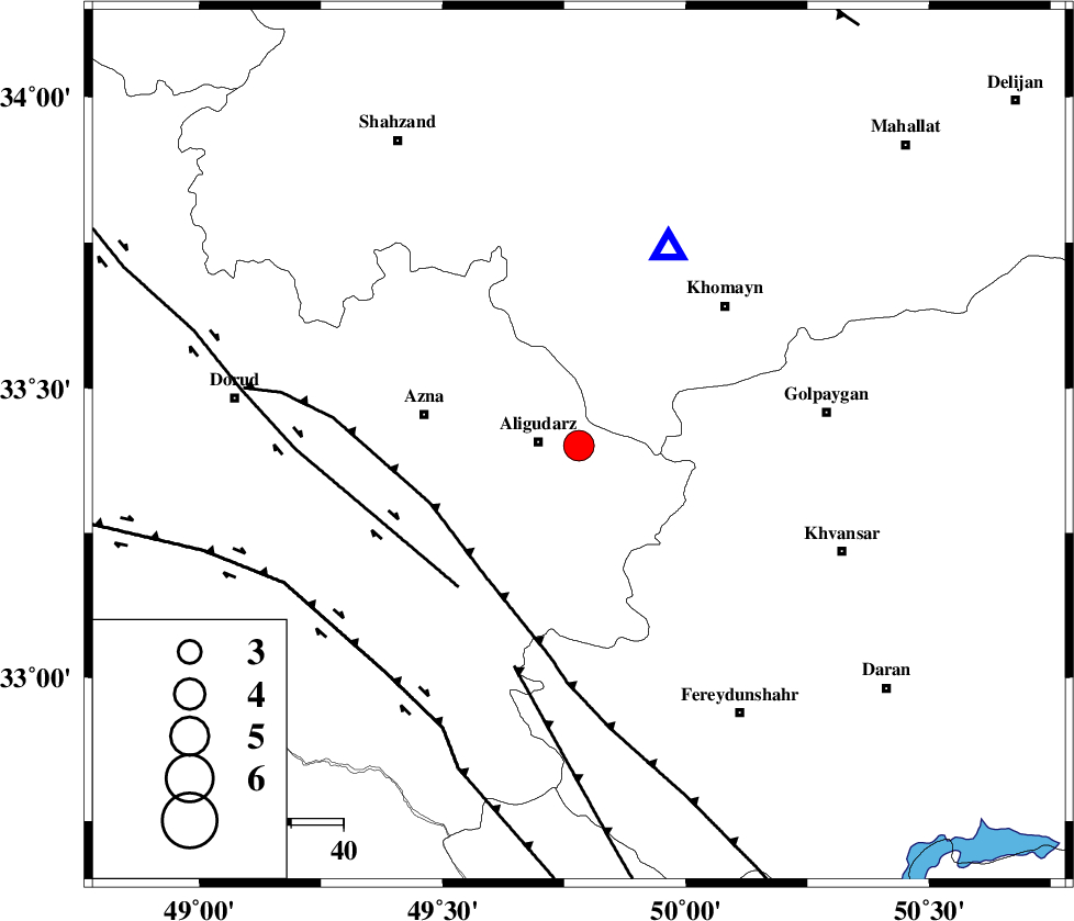
| Location | Lat:33.4 Lon: 49.78 |
| Region | Lorestan Province, 8 km Aligudarz |
Nearest Cities |
|
| 8 km of Aligudarz, Lorestan Province | |
| 10 km of Khameh sofla, Lorestan Province | |
| 14 km West of Dehnu, Markazi Province | |
| 17 km North East of Sur, Lorestan Province | |
| 18 km North of Shapoorabad, Lorestan Province | |
| Depth | 14 km |
| Agency | |
Faults within 150 km: |
|
| MAIN_ZAGROS_R_F (Length: 1106 km) , Distance to epicenter: 30 km | |
| DORUD (Length: 100 km) , Distance to epicenter: 36 km | |
| ARDAL_F (Length: 170 km) , Distance to epicenter: 44 km | |
| Number of Phases | 6 |
| RMS | 0.1 |
| Number of Stations | 6 |
| Error in Latitude | >3.8 km |
| Error in Longitude | 6.8 km |
| Error in Depth | 9.2 km |
Download waveform in seisan format
to download seisan software Click here
to access information about IIEES stations Click here
Amplitude | ||||||||
| UID | Agency | Station | Component | Amplitude | Period | Arrival Time | Proccessing Time | Signal Clip |
| 78908 | IIEES | ASAO | N | 1790.4 | 0.53 | 2011-05-12 05:38:30 | 2011-05-12 05:59:00 | n |
| 78909 | IIEES | SHGR | N | 1458.4 | 0.49 | 2011-05-12 05:38:38 | 2011-05-12 05:59:00 | n |
| 78910 | IIEES | GHVR | N | 1239.6 | 0.45 | 2011-05-12 05:38:40 | 2011-05-12 05:59:00 | n |
| 78911 | IIEES | GHVR | E | 2042.8 | 0.38 | 2011-05-12 05:38:41 | 2011-05-12 05:59:00 | n |
Phase | ||||||||||||
| Agency | Station | Component | Phase Type | Phase Quality | First Motion | Observed Arrival Time | Time Residual | Loc. Flag | Input Weight | Distance | Azimuth | |
| IIEES | KHMZ | Z | Pg | E | 2011-05-12 05:37:53 | -0.2 | y | 41.6 | 24 | |||
| IIEES | ASAO | Z | Pg | E | 2011-05-12 05:38:07 | 0.2 | y | 130 | 10 | |||
| IIEES | SHGR | Z | Pg | E | 2011-05-12 05:38:13 | 0 | y | 170 | 213 | |||
| IIEES | GHVR | Z | Pg | E | 2011-05-12 05:38:15 | 0 | y | 181 | 48 | |||
| IIEES | NASN | Z | Pn | E | 2011-05-12 05:38:29 | 0.1 | y | 290 | 102 | |||
| IIEES | AHRM | Z | Pn | E | 2011-05-12 05:38:57 | -0.1 | y | 523 | 164 | |||