
Magnitude |
:3 |
| Date & Time (UTC) | 2011-05-06 15:28:11.1 |
| Date & Time (Local) | 1390/2/16 19:58:11.1 |
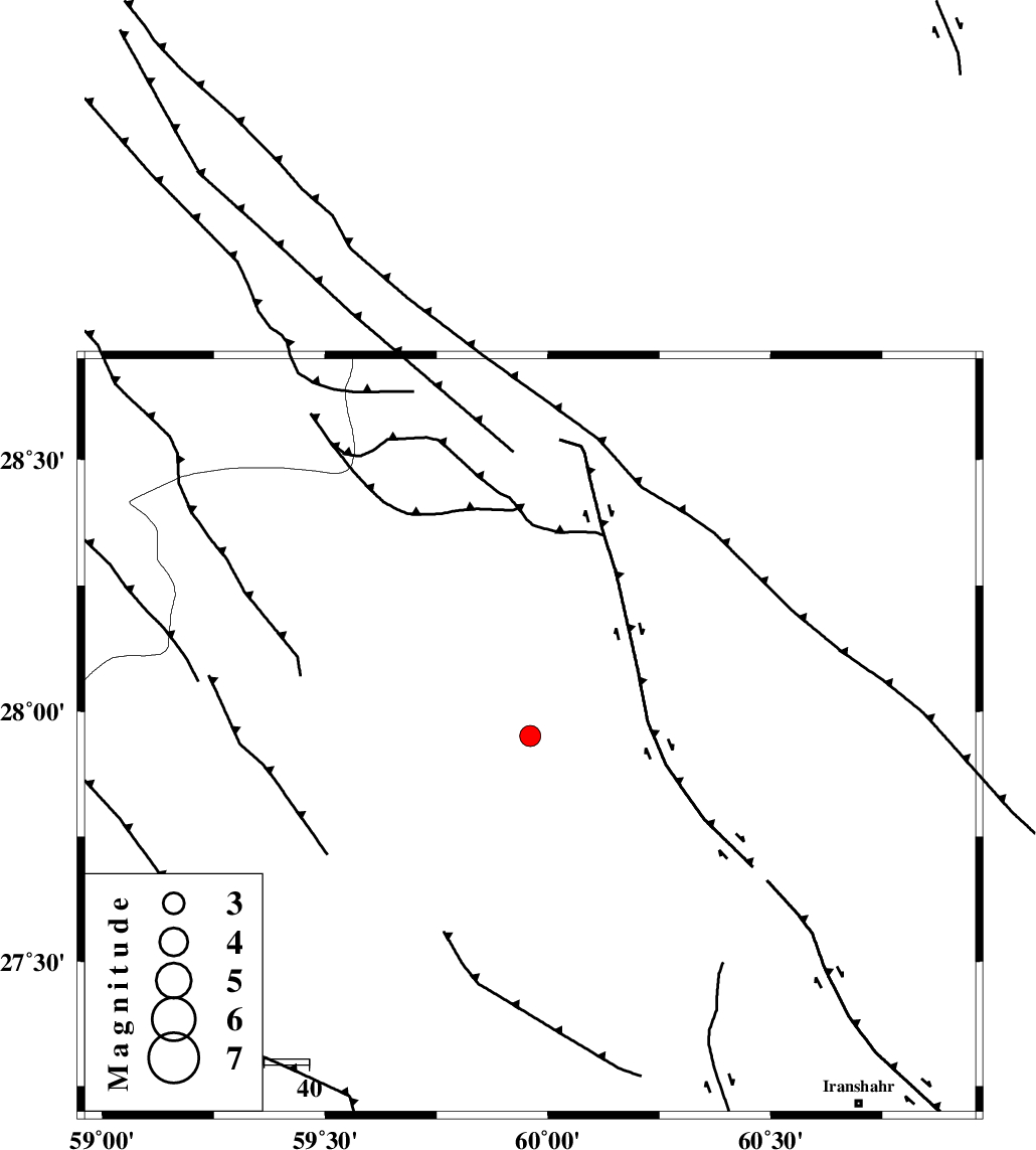
| Location | Lat:27.95 Lon: 59.96 |
| Region | Sistan va Baloochestan Province, 109 km North-West of Iranshahr |
Nearest Cities |
|
| 23 km North West of Bozman, Sistan va Baloochestan Province | |
| 25 km North West of Kiman, Sistan va Baloochestan Province | |
| 73 km South West of Goharshahr, Sistan va Baloochestan Province | |
| 75 km North East of Kalemursi, Sistan va Baloochestan Province | |
| 81 km North West of Karvandar, Sistan va Baloochestan Province | |
| Depth | 17 km |
| Agency | |
Faults within 150 km: |
|
| KASKIN_F (Length: 100 km) , Distance to epicenter: 33 km | |
| DAMAN_F (Length: 167 km) , Distance to epicenter: 47 km | |
| BAMPOSHT_F (Length: 156 km) , Distance to epicenter: 56 km | |
| Number of Phases | 4 |
| RMS | 0 |
| Number of Stations | 3 |
| Error in Latitude | >3 km |
| Error in Longitude | 5.7 km |
| Error in Depth | 11.9 km |
Download waveform in seisan format
to download seisan software Click here
to access information about IIEES stations Click here
Amplitude | ||||||||
| UID | Agency | Station | Component | Amplitude | Period | Arrival Time | Proccessing Time | Signal Clip |
| 78869 | IIEES | CHBR | E | 71 | 1.08 | 2011-05-06 15:29:40 | 2011-05-06 05:20:00 | n |
| 78870 | IIEES | CHBR | N | 60.9 | 0.75 | 2011-05-06 15:29:47 | 2011-05-06 05:20:00 | n |
| 78871 | IIEES | KRBR | N | 34.8 | 0.66 | 2011-05-06 15:30:01 | 2011-05-06 05:20:00 | n |
| 78872 | IIEES | KRBR | E | 32.5 | 0.11 | 2011-05-06 15:30:06 | 2011-05-06 05:20:00 | n |
Phase | ||||||||||||
| Agency | Station | Component | Phase Type | Phase Quality | First Motion | Observed Arrival Time | Time Residual | Loc. Flag | Input Weight | Distance | Azimuth | |
| IIEES | ZHSF | Z | Pg | E | 2011-05-06 15:28:44 | 0 | y | 201 | 23 | |||
| IIEES | ZHSF | E | Sg | E | 2011-05-06 15:29:08 | 0 | y | 201 | 23 | |||
| IIEES | CHBR | Z | Pn | E | 2011-05-06 15:28:51 | 0 | y | 266 | 169 | |||
| IIEES | KRBR | Z | Pn | E | 2011-05-06 15:29:06 | 0 | y | 385 | 307 | |||