
Magnitude |
:4 |
| Date & Time (UTC) | 2011-04-11 12:02:15.3 |
| Date & Time (Local) | 1390/1/22 16:32:15.3 |
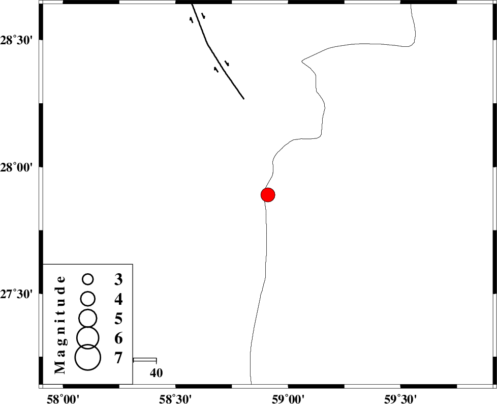
| Location | Lat:27.89 Lon: 58.91 |
| Region | Sistan va Baloochestan Province, 120 km East of Kahnuj |
Nearest Cities |
|
| 42 km South East of Borj-e abbasabad, Kerman Province | |
| 71 km North West of Kalemursi, Sistan va Baloochestan Province | |
| 88 km South East of Mardehak, Kerman Province | |
| 92 km South West of Hoseynabad, Kerman Province | |
| 92 km South of Mohammadabad-e gonbaki, Kerman Province | |
| Depth | 15 km |
| Agency | |
Faults within 150 km: |
|
| BAM_F (Length: 118 km) , Distance to epicenter: 43 km | |
| JIROFT_F (Length: 144 km) , Distance to epicenter: 108 km | |
| S_JAZMURIAN_F (Length: 91 km) , Distance to epicenter: 112 km | |
| Number of Phases | 4 |
| RMS | 0.2 |
| Number of Stations | 5 |
| Error in Latitude | >4.4 km |
| Error in Longitude | 3.1 km |
| Error in Depth | 0 km |
Download waveform in seisan format
to download seisan software Click here
to access information about IIEES stations Click here
Amplitude | ||||||||
| UID | Agency | Station | Component | Amplitude | Period | Arrival Time | Proccessing Time | Signal Clip |
| 78672 | IIEES | BNDS | E | 702.8 | 0.44 | 2011-04-11 12:03:37 | 2011-04-11 12:17:00 | n |
| 78673 | IIEES | BNDS | N | 1016.2 | 0.44 | 2011-04-11 12:03:41 | 2011-04-11 12:17:00 | n |
| 78674 | IIEES | KRBR | E | 766.4 | 0.64 | 2011-04-11 12:03:41 | 2011-04-11 12:17:00 | n |
| 78675 | IIEES | KRBR | N | 712.5 | 0.56 | 2011-04-11 12:03:45 | 2011-04-11 12:17:00 | n |
| 78676 | IIEES | GHIR | N | 80.6 | 0.52 | 2011-04-11 12:04:42 | 2011-04-11 12:17:00 | n |
| 78677 | IIEES | GHIR | E | 46.7 | 0.6 | 2011-04-11 12:04:44 | 2011-04-11 12:17:00 | n |
Phase | ||||||||||||
| Agency | Station | Component | Phase Type | Phase Quality | First Motion | Observed Arrival Time | Time Residual | Loc. Flag | Input Weight | Distance | Azimuth | |
| IIEES | ZHSF | Z | Pn | E | 2011-04-11 12:02:55 | 0.2 | y | 264 | 43 | |||
| IIEES | BNDS | Z | Pn | E | 2011-04-11 12:02:57 | 0.2 | y | 276 | 259 | |||
| IIEES | CHBR | N | Pn | E | 2011-04-11 12:02:59 | -0.1 | y | 298 | 148 | |||
| IIEES | KRBR | E | Pn | E | 2011-04-11 12:03:01 | -0.3 | y | 313 | 318 | |||