
Magnitude |
:3.4 |
| Date & Time (UTC) | 2011-01-31 12:35:13.0 |
| Date & Time (Local) | 1389/11/11 16:05:13.0 |
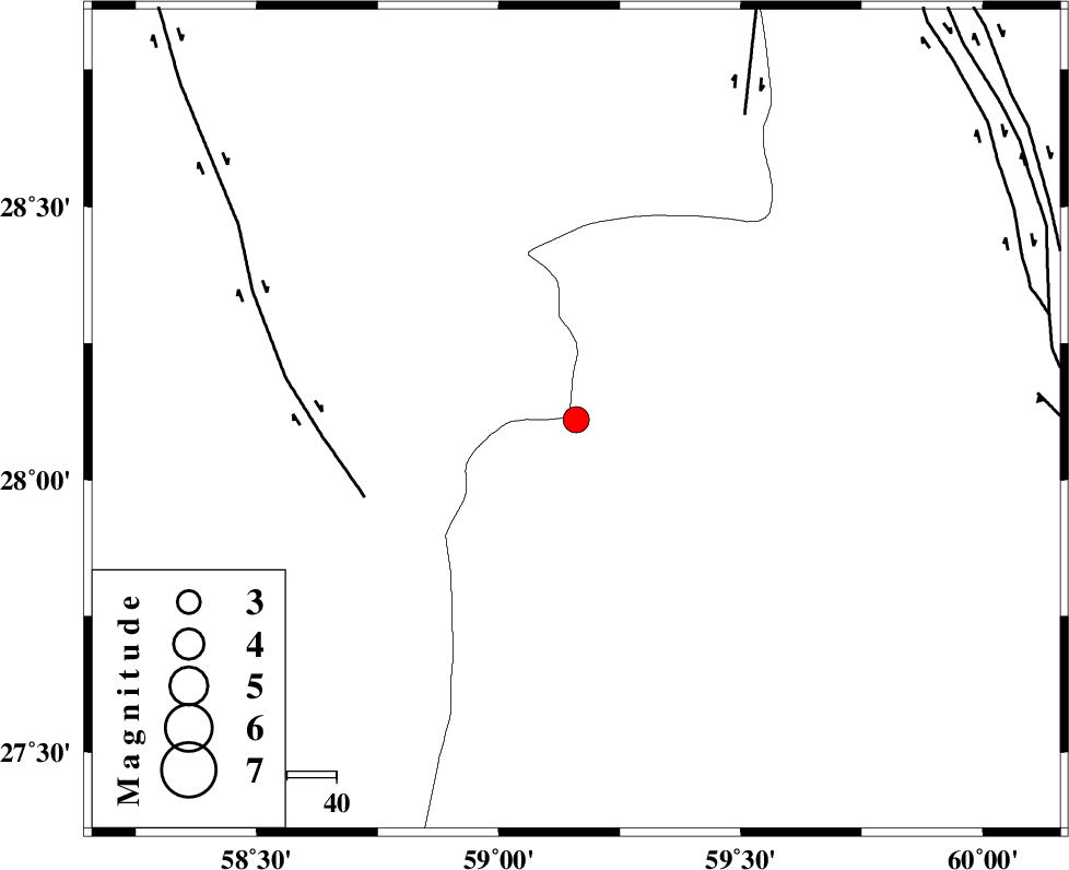
| Location | Lat:28.11 Lon: 59.16 |
| Region | Sistan va Baloochestan Province, 145 km North-East of Kahnuj |
Nearest Cities |
|
| 64 km North East of Borj-e abbasabad, Kerman Province | |
| 67 km South of Hoseynabad, Kerman Province | |
| 73 km South East of Mohammadabad-e gonbaki, Kerman Province | |
| 78 km North West of Kalemursi, Sistan va Baloochestan Province | |
| 88 km South East of Void, Kerman Province | |
| Depth | 15 km |
| Agency | |
Faults within 150 km: |
|
| BAM_F (Length: 118 km) , Distance to epicenter: 39 km | |
| KANURAK_F (Length: 135 km) , Distance to epicenter: 104 km | |
| KASKIN_F (Length: 100 km) , Distance to epicenter: 107 km | |
| Number of Phases | 4 |
| RMS | 0.2 |
| Number of Stations | 4 |
| Error in Latitude | >3.7 km |
| Error in Longitude | 2.8 km |
| Error in Depth | 0 km |
Download waveform in seisan format
to download seisan software Click here
to access information about IIEES stations Click here
Amplitude | ||||||||
| UID | Agency | Station | Component | Amplitude | Period | Arrival Time | Proccessing Time | Signal Clip |
| 77743 | IIEES | BNDS | N | 243.1 | 0.56 | 2011-01-31 12:36:41 | 2011-01-31 12:53:00 | n |
| 77744 | IIEES | BNDS | E | 213.5 | 0.48 | 2011-01-31 12:36:44 | 2011-01-31 12:53:00 | n |
| 77745 | IIEES | KRBR | N | 108.3 | 0.52 | 2011-01-31 12:36:45 | 2011-01-31 12:53:00 | n |
| 77746 | IIEES | KRBR | E | 101.1 | 0.72 | 2011-01-31 12:36:51 | 2011-01-31 12:53:00 | n |
Phase | ||||||||||||
| Agency | Station | Component | Phase Type | Phase Quality | First Motion | Observed Arrival Time | Time Residual | Loc. Flag | Input Weight | Distance | Azimuth | |
| IIEES | ZHSF | Z | Pn | E | 2011-01-31 12:35:49 | 0.1 | y | 229 | 43 | |||
| IIEES | BNDS | E | Pn | E | 2011-01-31 12:35:58 | 0.2 | y | 305 | 256 | |||
| IIEES | CHBR | Z | Pn | E | 2011-01-31 12:35:58 | -0.1 | y | 307 | 154 | |||
| IIEES | KRBR | Z | Pn | E | 2011-01-31 12:35:59 | -0.3 | y | 313 | 312 | |||