
Magnitude |
:3.6 |
| Date & Time (UTC) | 2010-12-16 17:43:00.2 |
| Date & Time (Local) | 1389/9/25 21:13:00.2 |
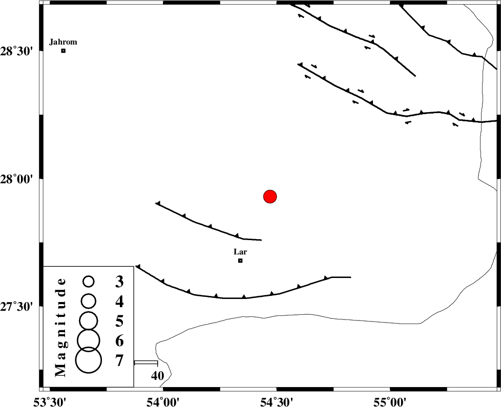
| Location | Lat:27.93 Lon: 54.47 |
| Region | Fars Province, 31 km North-East of Lar |
Nearest Cities |
|
| 10 km North of Dehkuyeh, Fars Province | |
| 27 km North of Latifi, Fars Province | |
| 31 km North East of Lar, Fars Province | |
| 43 km North East of Grash, Fars Province | |
| 44 km South East of Shahr-e pir, Fars Province | |
| Depth | 35 km |
| Agency | |
Faults within 150 km: |
|
| BERIZ_F (Length: 49 km) , Distance to epicenter: 19 km | |
| LAR_F (Length: 99 km) , Distance to epicenter: 43 km | |
| HZF2 (Length: 437 km) , Distance to epicenter: 56 km | |
| Number of Phases | 5 |
| RMS | 0.2 |
| Number of Stations | 4 |
| Error in Latitude | >5 km |
| Error in Longitude | 3.3 km |
| Error in Depth | 6.1 km |
Download waveform in seisan format
to download seisan software Click here
to access information about IIEES stations Click here
Amplitude | ||||||||
| UID | Agency | Station | Component | Amplitude | Period | Arrival Time | Proccessing Time | Signal Clip |
| 75550 | IIEES | GHIR | N | 979.2 | 0.76 | 2010-12-16 17:43:50 | 2010-12-16 07:14:00 | n |
| 75551 | IIEES | GHIR | E | 804.9 | 0.48 | 2010-12-16 17:43:54 | 2010-12-16 07:14:00 | n |
| 75552 | IIEES | KRBR | N | 176.6 | 0.52 | 2010-12-16 17:44:34 | 2010-12-16 07:14:00 | n |
| 75553 | IIEES | KRBR | E | 226.2 | 0.52 | 2010-12-16 17:44:38 | 2010-12-16 07:14:00 | n |
Phase | ||||||||||||
| Agency | Station | Component | Phase Type | Phase Quality | First Motion | Observed Arrival Time | Time Residual | Loc. Flag | Input Weight | Distance | Azimuth | |
| IIEES | GHIR | Z | Pg | E | 2010-12-16 17:43:25 | 0 | y | 151 | 285 | |||
| IIEES | KRBR | Z | Pn | E | 2010-12-16 17:43:46 | 0.3 | y | 319 | 44 | |||
| IIEES | KRBR | N | Sg | E | 2010-12-16 17:44:27 | -0.1 | y | 319 | 44 | |||
| IIEES | NASN | Z | Pn | E | 2010-12-16 17:44:15 | -0.2 | y | 563 | 344 | |||
| IIEES | CHBR | Z | Pn | E | 2010-12-16 17:44:26 | -0.2 | y | 652 | 112 | |||