
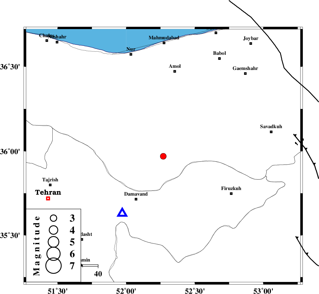
Magnitude |
:2.8 |
| Date & Time (UTC) | 2010-11-14 20:12:15.2 |
| Date & Time (Local) | 1389/8/23 23:42:15.2 |
| Location | Lat:35.97 Lon: 52.27 |
| Region | Mazandaran Province, 34 km North-East of Damavand |
Nearest Cities |
|
| 3 km of Baijan, Mazandaran Province | |
| 10 km North of Gaznak, Mazandaran Province | |
| 13 km North East of Rineh, Mazandaran Province | |
| 30 km North West of Arjomand, Tehran Province | |
| 32 km South East of Pil, Mazandaran Province | |
| Depth | 6 km |
| Agency | |
Faults within 150 km: |
|
| MOSHA_F (Length: 234 km) , Distance to epicenter: 28 km | |
| N_ALBORZ_F (Length: 360 km) , Distance to epicenter: 34 km | |
| KANDOVAN_F (Length: 90 km) , Distance to epicenter: 42 km | |
| Number of Phases | 7 |
| RMS | 0.1 |
| Number of Stations | 6 |
| Error in Latitude | >2 km |
| Error in Longitude | 2.9 km |
| Error in Depth | 4.1 km |
Download waveform in seisan format
to download seisan software Click here
to access information about IIEES stations Click here
Amplitude | ||||||||
| UID | Agency | Station | Component | Amplitude | Period | Arrival Time | Proccessing Time | Signal Clip |
| 73470 | IIEES | DAMV | N | 1656.9 | 0.12 | 2010-11-14 20:12:31 | 2010-11-14 08:29:00 | n |
| 73471 | IIEES | DAMV | E | 1396.5 | 0.08 | 2010-11-14 20:12:31 | 2010-11-14 08:29:00 | n |
| 73472 | IIEES | GHVR | N | 59.4 | 0.6 | 2010-11-14 20:13:17 | 2010-11-14 08:29:00 | n |
| 73473 | IIEES | GHVR | E | 84.4 | 0.56 | 2010-11-14 20:13:18 | 2010-11-14 08:29:00 | n |
Phase | ||||||||||||
| Agency | Station | Component | Phase Type | Phase Quality | First Motion | Observed Arrival Time | Time Residual | Loc. Flag | Input Weight | Distance | Azimuth | |
| IIEES | DAMV | Z | P | E | 2010-11-14 20:12:23 | 0.1 | y | 46.4 | 215 | |||
| IIEES | CHTH | Z | P | E | 2010-11-14 20:12:33 | 0 | y | 103 | 266 | |||
| IIEES | GHVR | Z | P | E | 2010-11-14 20:12:46 | 0.1 | y | 190 | 210 | |||
| IIEES | GHVR | E | Sg | E | 2010-11-14 20:13:11 | -0.1 | y | 190 | 210 | |||
| IIEES | ASAO | Z | P | E | 2010-11-14 20:12:56 | 0 | y | 258 | 233 | |||
| IIEES | SHRO | Z | P | E | 2010-11-14 20:13:05 | -0.1 | y | 338 | 88 | |||
| IIEES | NASN | Z | P | E | 2010-11-14 20:13:08 | 0.1 | y | 356 | 172 | |||