
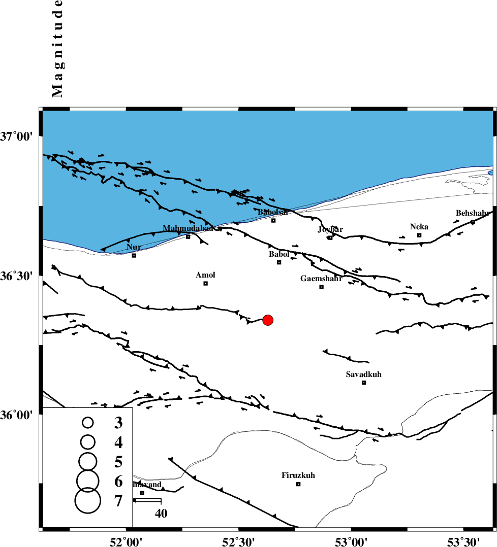
Magnitude |
:2.9 |
| Date & Time (UTC) | 2010-11-10 03:48:35.7 |
| Date & Time (Local) | 1389/8/19 07:18:35.7 |
| Location | Lat:36.34 Lon: 52.63 |
| Region | Mazandaran Province, 24 km South of Babol |
Nearest Cities |
|
| 8 km of Khoshrud, Mazandaran Province | |
| 9 km North of Derazkola, Mazandaran Province | |
| 14 km South of Paeen-e ahmad chalehpey, Mazandaran Province | |
| 17 km North of Firoozjah-e sabet, Mazandaran Province | |
| 20 km North West of Kij khalil, Mazandaran Province | |
| Depth | 6 km |
| Agency | |
Faults within 150 km: |
|
| KHAZAR_F (Length: 523 km) , Distance to epicenter: 4 km | |
| N_ALBORZ_F (Length: 360 km) , Distance to epicenter: 17 km | |
| MOSHA_F (Length: 234 km) , Distance to epicenter: 72 km | |
| Number of Phases | 7 |
| RMS | 0.1 |
| Number of Stations | 6 |
| Error in Latitude | >2.9 km |
| Error in Longitude | 5.1 km |
| Error in Depth | 4.1 km |
Download waveform in seisan format
to download seisan software Click here
to access information about IIEES stations Click here
Amplitude | ||||||||
| UID | Agency | Station | Component | Amplitude | Period | Arrival Time | Proccessing Time | Signal Clip |
| 73150 | IIEES | DAMV | E | 378 | 0.56 | 2010-11-10 03:49:06 | 2010-11-10 04:01:00 | n |
| 73151 | IIEES | GHVR | N | 90.4 | 0.4 | 2010-11-10 03:49:51 | 2010-11-10 04:01:00 | n |
| 73152 | IIEES | GHVR | E | 99.6 | 0.36 | 2010-11-10 03:49:51 | 2010-11-10 04:01:00 | n |
| 73153 | IIEES | ASAO | E | 25 | 0.44 | 2010-11-10 03:50:05 | 2010-11-10 04:01:00 | n |
| 73154 | IIEES | ASAO | N | 34.5 | 0.4 | 2010-11-10 03:50:05 | 2010-11-10 04:01:00 | n |
Phase | ||||||||||||
| Agency | Station | Component | Phase Type | Phase Quality | First Motion | Observed Arrival Time | Time Residual | Loc. Flag | Input Weight | Distance | Azimuth | |
| IIEES | DAMV | Z | Pg | E | 2010-11-10 03:48:52 | -0.1 | y | 98.5 | 218 | |||
| IIEES | DAMV | E | Sg | E | 2010-11-10 03:49:05 | 0 | y | 98.5 | 218 | |||
| IIEES | CHTH | Z | Pg | E | 2010-11-10 03:49:00 | -0.1 | y | 144 | 251 | |||
| IIEES | GHVR | Z | Pn | E | 2010-11-10 03:49:14 | 0.1 | y | 241 | 212 | |||
| IIEES | ASAO | Z | P | E | 2010-11-10 03:49:22 | 0.1 | y | 309 | 231 | |||
| IIEES | KHMZ | Z | P | E | 2010-11-10 03:49:31 | 0.1 | y | 377 | 221 | |||
| IIEES | NASN | Z | P | E | 2010-11-10 03:49:33 | -0.1 | y | 393 | 178 | |||