
Magnitude |
:3 |
| Date & Time (UTC) | 2010-10-09 00:22:09.8 |
| Date & Time (Local) | 1389/7/17 03:52:09.8 |
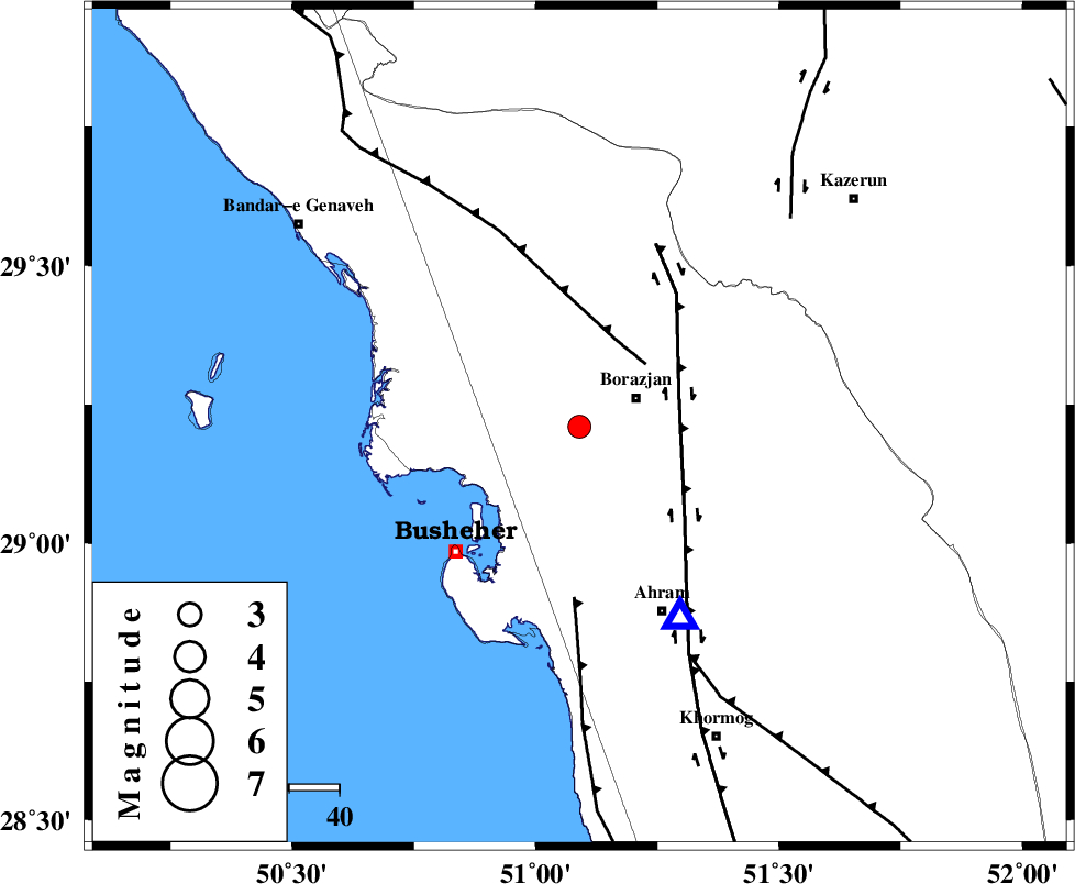
| Location | Lat:29.21 Lon: 51.09 |
| Region | Bushehr Province, 12 km West of Borazjan |
Nearest Cities |
|
| 8 km of Ziyarat, Bushehr Province | |
| 12 km North West of Sarkareh, Bushehr Province | |
| 13 km West of Borazjan, Bushehr Province | |
| 15 km East of Shabankareh, Bushehr Province | |
| 18 km East of Kareband, Bushehr Province | |
| Depth | 18 km |
| Agency | |
Faults within 150 km: |
|
| ZFF3 (Length: 125 km) , Distance to epicenter: 18 km | |
| BORAZJAN_F (Length: 168 km) , Distance to epicenter: 21 km | |
| ZFF2 (Length: 84 km) , Distance to epicenter: 34 km | |
| Number of Phases | 4 |
| RMS | 0.1 |
| Number of Stations | 3 |
| Error in Latitude | >4.4 km |
| Error in Longitude | 4.3 km |
| Error in Depth | 6.1 km |
Download waveform in seisan format
to download seisan software Click here
to access information about IIEES stations Click here
Amplitude | ||||||||
| UID | Agency | Station | Component | Amplitude | Period | Arrival Time | Proccessing Time | Signal Clip |
| 71630 | IIEES | AHRM | N | 1169.2 | 0.28 | 2010-10-09 00:22:26 | 2010-10-09 12:32:00 | n |
| 71631 | IIEES | AHRM | E | 1268.1 | 0.56 | 2010-10-09 00:22:26 | 2010-10-09 12:32:00 | n |
| 71632 | IIEES | GHIR | E | 180 | 0.44 | 2010-10-09 00:23:19 | 2010-10-09 12:32:00 | n |
| 71633 | IIEES | GHIR | N | 151.7 | 0.68 | 2010-10-09 00:23:21 | 2010-10-09 12:32:00 | n |
Phase | ||||||||||||
| Agency | Station | Component | Phase Type | Phase Quality | First Motion | Observed Arrival Time | Time Residual | Loc. Flag | Input Weight | Distance | Azimuth | |
| IIEES | AHRM | Z | Pg | E | 2010-10-09 00:22:17 | 0.1 | y | 43.3 | 153 | |||
| IIEES | GHIR | Z | Pn | E | 2010-10-09 00:22:43 | -0.2 | y | 211 | 119 | |||
| IIEES | GHIR | N | Sg | E | 2010-10-09 00:23:09 | 0 | y | 211 | 119 | |||
| IIEES | NASN | N | Pn | E | 2010-10-09 00:23:10 | 0.1 | y | 430 | 22 | |||