
Magnitude |
:3.4 |
| Date & Time (UTC) | 2010-09-28 22:53:27.7 |
| Date & Time (Local) | 1389/7/7 02:23:27.7 |
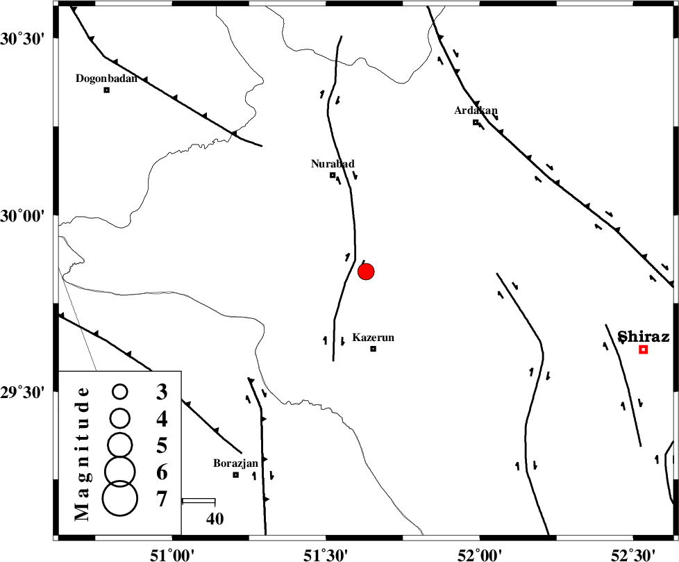
| Location | Lat:29.84 Lon: 51.63 |
| Region | Fars Province, 24 km North of Kazerun |
Nearest Cities |
|
| 4 km North of Seyyed hasan, Fars Province | |
| 8 km North of Nodan, Fars Province | |
| 19 km North of Deris, Fars Province | |
| 24 km North of Kazerun, Fars Province | |
| 28 km North East of Kamaraj, Fars Province | |
| Depth | 14 km |
| Agency | |
Faults within 150 km: |
|
| KAZERUN_F (Length: 96 km) , Distance to epicenter: 5 km | |
| KAREBASS_F (Length: 98 km) , Distance to epicenter: 41 km | |
| BORAZJAN_F (Length: 168 km) , Distance to epicenter: 50 km | |
| Number of Phases | 4 |
| RMS | 0.2 |
| Number of Stations | 3 |
| Error in Latitude | >12.1 km |
| Error in Longitude | 6 km |
| Error in Depth | 34.6 km |
Download waveform in seisan format
to download seisan software Click here
to access information about IIEES stations Click here
Amplitude | ||||||||
| UID | Agency | Station | Component | Amplitude | Period | Arrival Time | Proccessing Time | Signal Clip |
| 71190 | IIEES | AHRM | E | 1064.6 | 0 | 2010-09-28 22:54:07 | 2010-09-28 11:34:00 | n |
| 71191 | IIEES | AHRM | N | 997.8 | 0.47 | 2010-09-28 22:54:07 | 2010-09-28 11:34:00 | n |
| 71192 | IIEES | GHIR | N | 418.8 | 1.34 | 2010-09-28 22:54:37 | 2010-09-28 11:34:00 | n |
| 71193 | IIEES | GHIR | E | 442.3 | 0.52 | 2010-09-28 22:54:40 | 2010-09-28 11:34:00 | n |
| 71194 | IIEES | NASN | N | 43.6 | 0.18 | 2010-09-28 22:54:59 | 2010-09-28 11:34:00 | n |
Phase | ||||||||||||
| Agency | Station | Component | Phase Type | Phase Quality | First Motion | Observed Arrival Time | Time Residual | Loc. Flag | Input Weight | Distance | Azimuth | |
| IIEES | AHRM | Z | Pg | E | 2010-09-28 22:53:46 | 0.1 | y | 113 | 197 | |||
| IIEES | GHIR | Z | Pg | E | 2010-09-28 22:54:03 | -0.3 | y | 217 | 142 | |||
| IIEES | GHIR | E | Sg | E | 2010-09-28 22:54:29 | 0.2 | y | 217 | 142 | |||
| IIEES | NASN | Z | Pn | E | 2010-09-28 22:54:18 | 0 | y | 347 | 19 | |||